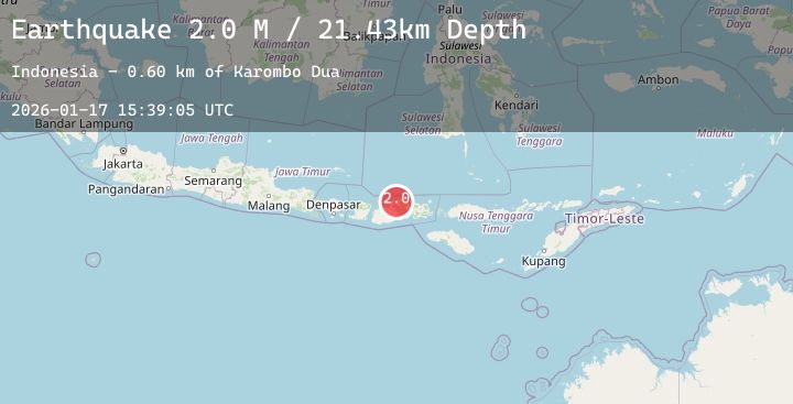
Earthquake Sumbawa Region, Indonesia
Sat, 17 Jan 2026 15:39:05 GMT
Time4 hours ago
Location
-8.2181, 117.7402
Depth
21.4 KM
Event Summary
A 2.0 magnitude earthquake struck on Sumbawa Region, Indonesia, at Sat, 17 Jan 2026 15:39:05 GMT. Depth: 21.42683km. Reviewed by BMKG seismologists, this minor quake occurred at a magnitude type of M.
Magnitude
2.0
M
Source
BMKG
Intensity
-
Agency Reports
1 Sources| Source | Magnitude | Depth | Time |
|---|---|---|---|
| BMKGPrimary | 2.0 | 21 km | 4 hours ago |
Earthquake Details
AutomaticEvent IDbmg2026bela
Tsunami PotentialNo
Magnitude TypeM
Nearest Places
- Latonda Dua0.7 km
- Doro Kedindi1.0 km
- Doro Batu1.5 km
- Latonda Satu1.9 km
- Doro Kadindi2.0 km
Comments
Join the discussion about this event.
Latest Earthquakes
2.3Mag
Northern Sumatra, Indonesia
Time4 hours ago
Depth7.51 km
SourceBMKG (Automatic)
3.3Mag
Timor Region
Time4 hours ago
Depth9.73 km
SourceBMKG (Automatic)
3.5Mag
Talaud Islands, Indonesia
Time4 hours ago
Depth89.49 km
SourceBMKG (Automatic)
2.7Mag
Timor Region
Time5 hours ago
Depth6.59 km
SourceBMKG (Automatic)
2.5Mag
Savu Sea
Time5 hours ago
Depth15.96 km
SourceBMKG (Automatic)
Nearby Earthquakes
2.4Mag
Bali Sea
Time5 hours ago
Depth6.76 km
SourceBMKG (Automatic)
3.1Mag
Bali Sea
Time9 hours ago
Depth10.00 km
SourceBMKG (Automatic)
2.1Mag
Sumbawa Region, Indonesia
Time12 hours ago
Depth79.53 km
SourceBMKG (Automatic)
2.3Mag
Sumbawa Region, Indonesia
Time16 hours ago
Depth10.00 km
SourceBMKG (Automatic)
2.4Mag
Sumbawa Region, Indonesia
Time1 day ago
Depth17.58 km
SourceBMKG (Automatic)