Earthquake Off West Coast of Northern Sumatra
Wed, 28 Jan 2026 12:29:20 GMT
Time1 hour ago
Location
4.6657, 94.3105
Depth
31.8 KM
Event Summary
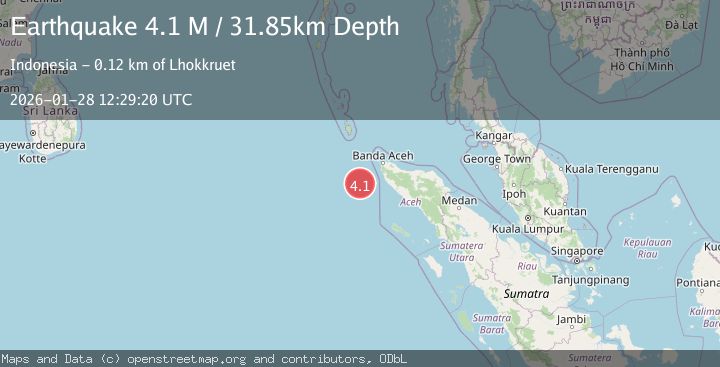
A 4.1 magnitude earthquake struck on Off West Coast of Northern Sumatra, at Wed, 28 Jan 2026 12:29:20 GMT. Depth: 31.847912km. Reviewed by BMKG seismologists, this light quake occurred at a magnitude type of M.
Magnitude
4.1
M
Source
BMKG
Intensity
-
Agency Reports
1 Sources| Source | Magnitude | Depth | Time |
|---|---|---|---|
| BMKGPrimary | 4.1 | 32 km | 1 hour ago |
Earthquake Details
AutomaticEvent IDbmg2026byhh
Tsunami PotentialNo
Magnitude TypeM
Nearest Places
- Nicobar-Simeulue Basin42.7 km
- Karang Sindoro110.0 km
- Batu Burung116.7 km
- Babahparu117.5 km
- Ujung Sudhen118.6 km
Comments
Join the discussion about this event.
Latest Earthquakes
1.8Mag
14 km NE of Indio, CA
Time1 hour ago
Depth2.39 km
SourceUSGS (Automatic)
1.3Mag
23 km SW of Snyder, Texas
Time1 hour ago
Depth2.69 km
SourceUSGS (Automatic)
2.5Mag
Minahassa Peninsula, Sulawesi
Time1 hour ago
Depth47.66 km
SourceBMKG (Automatic)
2.6Mag
ISLAND OF HAWAII, HAWAII
Time2 hours ago
Depth39.60 km
SourceHV (Automatic)
3.1Mag
HOKKAIDO, JAPAN REGION
Time2 hours ago
Depth0.00 km
SourceJMA (Automatic)
Nearby Earthquakes
2.7Mag
Northern Sumatra, Indonesia
Time1 week ago
Depth5.57 km
SourceBMKG (Automatic)
3.4Mag
Off West Coast of Northern Sumatra
Time6 days ago
Depth97.27 km
SourceBMKG (Automatic)
2.8Mag
Northern Sumatra, Indonesia
Time10 hours ago
Depth10.00 km
SourceBMKG (Automatic)
2.4Mag
Northern Sumatra, Indonesia
Time1 day ago
Depth7.88 km
SourceBMKG (Automatic)
2.3Mag
Northern Sumatra, Indonesia
Time5 days ago
Depth49.78 km
SourceBMKG (Automatic)