Earthquake South of Bali, Indonesia
Fri, 30 Jan 2026 08:50:47 GMT
Time1 hour ago
Location
-9.3321, 115.7568
Depth
37.7 KM
Event Summary
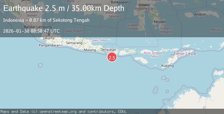
A 2.5 magnitude earthquake struck on South of Bali, Indonesia, at Fri, 30 Jan 2026 08:50:47 GMT. Depth: 37.728539km. Reviewed by BMKG seismologists, this minor quake occurred at a magnitude type of M.
Magnitude
2.5
M
Source
BMKG
Intensity
-
Agency Reports
1 Sources| Source | Magnitude | Depth | Time |
|---|---|---|---|
| BMKGPrimary | 2.5 | 38 km | 1 hour ago |
Earthquake Details
AutomaticEvent IDbmg2026cbrc
Tsunami PotentialNo
Magnitude TypeM
Nearest Places
- Pulau Sophialouisa52.8 km
- Gili Sarangburung54.8 km
- Gili Luah55.2 km
- Gili Loangberayun55.6 km
- Tanjung Panggang56.0 km
Comments
Join the discussion about this event.
Latest Earthquakes
3.1Mag
Southwest of Sumatra, Indonesia
Time1 hour ago
Depth26.83 km
SourceBMKG (Automatic)
0.8Mag
17 km NE of Pine Valley, CA
Time1 hour ago
Depth4.90 km
SourceUSGS (Automatic)
3.2Mag
Near North Coast of West Papua
Time1 hour ago
Depth10.00 km
SourceBMKG (Automatic)
0.7Mag
7 km S of Pearblossom, CA
Time1 hour ago
Depth9.52 km
SourceUSGS (Automatic)
3.1Mag
Flores Region, Indonesia
Time1 hour ago
Depth85.93 km
SourceBMKG (Automatic)
Nearby Earthquakes
2.9Mag
South of Bali, Indonesia
Time6 days ago
Depth27.22 km
SourceBMKG (Automatic)
2.6Mag
South of Bali, Indonesia
Time3 days ago
Depth158.81 km
SourceBMKG (Automatic)
2.7Mag
Sumbawa Region, Indonesia
Time1 week ago
Depth29.18 km
SourceBMKG (Automatic)
2.2Mag
Bali Region, Indonesia
Time6 days ago
Depth84.98 km
SourceBMKG (Automatic)
2.6Mag
South of Bali, Indonesia
Time4 days ago
Depth19.30 km
SourceBMKG (Automatic)