Earthquake Northern Molucca Sea
Fri, 30 Jan 2026 12:20:49 GMT
Time3 hours ago
Location
1.1717, 126.7256
Depth
52.2 KM
Event Summary
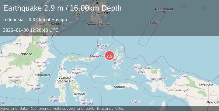
A 2.8 magnitude earthquake struck on Northern Molucca Sea, at Fri, 30 Jan 2026 12:20:49 GMT. Depth: 52.209515km. Reviewed by BMKG seismologists, this minor quake occurred at a magnitude type of M.
Magnitude
2.8
M
Source
BMKG
Intensity
-
Agency Reports
1 Sources| Source | Magnitude | Depth | Time |
|---|---|---|---|
| BMKGPrimary | 2.8 | 52 km | 3 hours ago |
Earthquake Details
AutomaticEvent IDbmg2026cbya
Tsunami PotentialNo
Magnitude TypeM
Nearest Places
- Tanjung Geranomaderi39.5 km
- Kelurahan Bido40.0 km
- Kelurahan Lelewi41.1 km
- Pulau Mayu41.4 km
- Kecamatan Pulau Batang Dua41.4 km
Comments
Join the discussion about this event.
Latest Earthquakes
3.1Mag
OFFSHORE EL SALVADOR
Time3 hours ago
Depth27.00 km
SourceINET (Automatic)
1.2Mag
2 km SW of Hollister, CA
Time3 hours ago
Depth7.56 km
SourceUSGS (Automatic)
3.0Mag
Minahassa Peninsula, Sulawesi
Time3 hours ago
Depth245.80 km
SourceBMKG (Automatic)
2.0Mag
44 km NNW of Valdez, Alaska
Time3 hours ago
Depth23.60 km
SourceUSGS (Automatic)
2.8Mag
23 km W of Akhiok, Alaska
Time3 hours ago
Depth0.60 km
SourceUSGS (Automatic)
Nearby Earthquakes
2.6Mag
Northern Molucca Sea
Time6 days ago
Depth61.16 km
SourceBMKG (Automatic)
2.8Mag
Northern Molucca Sea
Time2 days ago
Depth6.77 km
SourceBMKG (Automatic)
3.1Mag
Northern Molucca Sea
Time3 days ago
Depth31.63 km
SourceBMKG (Automatic)
4.7Mag
Northern Molucca Sea
Time1 week ago
Depth23.34 km
SourceBMKG (Automatic)
3.1Mag
Northern Molucca Sea
Time5 days ago
Depth27.94 km
SourceBMKG (Automatic)