Earthquake Near North Coast of West Papua
Sun, 01 Feb 2026 22:29:46 GMT
Time22 hours ago
Location
-1.7332, 139.1089
Depth
10.0 KM
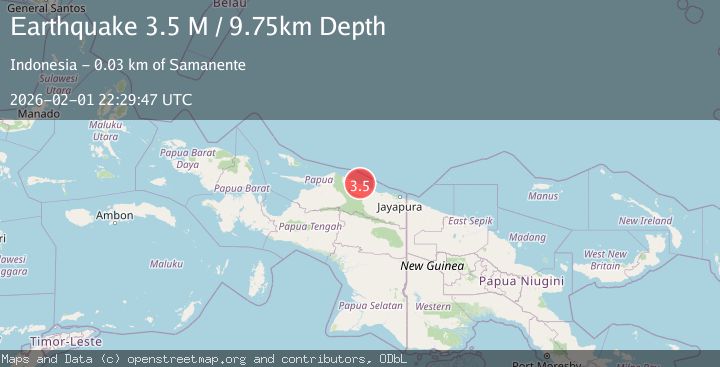
Event Summary
A 3.1 magnitude earthquake struck on Near North Coast of West Papua, at Sun, 01 Feb 2026 22:29:46 GMT. Depth: 10km. Reviewed by BMKG seismologists, this minor quake occurred at a magnitude type of M.
Magnitude
3.1
M
Source
BMKG
Intensity
-
Agency Reports
1 Sources| Source | Magnitude | Depth | Time |
|---|---|---|---|
| BMKGPrimary | 3.1 | 10 km | 22 hours ago |
Earthquake Details
AutomaticEvent IDbmg2026cgjd
Tsunami PotentialNo
Magnitude TypeM
Nearest Places
- Wakde24.5 km
- Pulau Insumoar25.0 km
- Pulau-pulau Wakde25.7 km
- Insumanai27.0 km
- Air Tementu28.6 km
Comments
Join the discussion about this event.
Latest Earthquakes
4.5Mag
Southern Sumatra, Indonesia
Time22 hours ago
Depth23.34 km
SourceBMKG (Automatic)
1.3Mag
22 km WNW of Garden City, Texas
Time22 hours ago
Depth2.90 km
SourceUSGS (Automatic)
1.6Mag
9 km SSE of Girdwood, Alaska
Time22 hours ago
Depth13.90 km
SourceUSGS (Automatic)
2.5Mag
ALBANIA
Time22 hours ago
Depth15.00 km
SourceIGEO (Automatic)
1.4Mag
14 km NE of Ridgecrest, CA
Time22 hours ago
Depth8.20 km
SourceUSGS (Automatic)
Nearby Earthquakes
3.2Mag
Near North Coast of West Papua
Time5 days ago
Depth10.00 km
SourceBMKG (Automatic)
2.5Mag
Near North Coast of West Papua
Time1 week ago
Depth30.91 km
SourceBMKG (Automatic)
2.9Mag
Near North Coast of West Papua
Time23 hours ago
Depth14.41 km
SourceBMKG (Automatic)
2.7Mag
West Papua, Indonesia
Time1 week ago
Depth73.44 km
SourceBMKG (Automatic)
3.2Mag
Near North Coast of West Papua
Time1 week ago
Depth25.99 km
SourceBMKG (Automatic)