Earthquake Off West Coast of Northern Sumatra
Mon, 02 Feb 2026 15:05:55 GMT
Time2 hours ago
Location
2.5746, 95.6815
Depth
10.0 KM
Event Summary
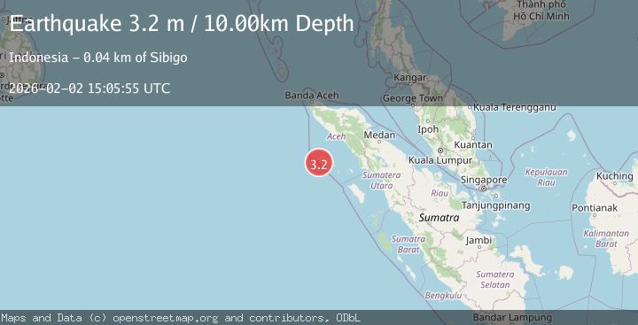
A 3.2 magnitude earthquake struck on Off West Coast of Northern Sumatra, at Mon, 02 Feb 2026 15:05:55 GMT. Depth: 10km. Reviewed by BMKG seismologists, this minor quake occurred at a magnitude type of M.
Magnitude
3.2
M
Source
BMKG
Intensity
-
Agency Reports
1 Sources| Source | Magnitude | Depth | Time |
|---|---|---|---|
| BMKGPrimary | 3.2 | 10 km | 2 hours ago |
Earthquake Details
AutomaticEvent IDbmg2026chpz
Tsunami PotentialNo
Magnitude TypeM
Nearest Places
- Karang Sotan14.0 km
- Ujung Uluayan14.7 km
- Pulau Lekon15.8 km
- Padangunui16.1 km
- Luan Alang16.4 km
Comments
Join the discussion about this event.
Latest Earthquakes
2.2Mag
31 km E of Skwentna, Alaska
Time2 hours ago
Depth64.10 km
SourceUSGS (Automatic)
2.3Mag
Flores Region, Indonesia
Time2 hours ago
Depth38.94 km
SourceBMKG (Automatic)
1.0Mag
20 km NNE of Indio, CA
Time2 hours ago
Depth6.36 km
SourceUSGS (Automatic)
2.5Mag
Java, Indonesia
Time2 hours ago
Depth11.49 km
SourceBMKG (Automatic)
2.2Mag
WESTERN TURKEY
Time2 hours ago
Depth11.10 km
SourceKOERI (Automatic)
Nearby Earthquakes
4.4Mag
Northern Sumatra, Indonesia
Time4 days ago
Depth10.00 km
SourceBMKG (Automatic)
2.7Mag
Northern Sumatra, Indonesia
Time3 days ago
Depth8.31 km
SourceBMKG (Automatic)
2.5Mag
Northern Sumatra, Indonesia
Time1 week ago
Depth10.00 km
SourceBMKG (Automatic)
3.0Mag
OFF W COAST OF NORTHERN SUMATRA
Time6 days ago
Depth64.00 km
SourceBMKG (Automatic)
4.0Mag
Northern Sumatra, Indonesia
Time18 hours ago
Depth5.00 km
SourceBMKG (Automatic)