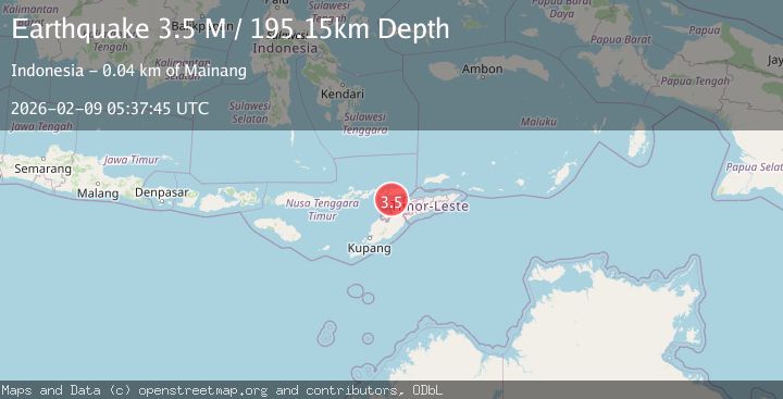
Earthquake Timor Region
Mon, 09 Feb 2026 05:37:46 GMT
Time1 hour ago
Location
-8.6152, 124.5196
Depth
197.8 KM
Event Summary
A 2.6 magnitude earthquake struck on Timor Region, at Mon, 09 Feb 2026 05:37:46 GMT. Depth: 197.778305km. Reviewed by BMKG seismologists, this minor quake occurred at a magnitude type of M.
Magnitude
2.6
M
Source
BMKG
Intensity
-
Agency Reports
1 Sources| Source | Magnitude | Depth | Time |
|---|---|---|---|
| BMKGPrimary | 2.6 | 198 km | 1 hour ago |
Earthquake Details
AutomaticEvent IDbmg2026ctrt
Tsunami PotentialNo
Magnitude TypeM
Nearest Places
- Tanjung Sifala19.4 km
- Sifala20.0 km
- Baringbur20.2 km
- Mol Baringbur20.3 km
- Alu Ihirgahal20.4 km
Comments
Join the discussion about this event.
Latest Earthquakes
1.1Mag
7 km NW of The Geysers, CA
Time1 hour ago
Depth2.36 km
SourceUSGS (Automatic)
1.7Mag
10 km SW of Brentwood, CA
Time2 hours ago
Depth10.49 km
SourceUSGS (Automatic)
1.2Mag
WESTERN TURKEY
Time2 hours ago
Depth5.40 km
SourceAFAD (Automatic)
1.9Mag
CENTRAL TURKEY
Time2 hours ago
Depth7.00 km
SourceAFAD (Automatic)
1.6Mag
7 km WSW of Beaumont, CA
Time2 hours ago
Depth16.18 km
SourceUSGS (Automatic)
Nearby Earthquakes
2.1Mag
Timor Region
Time2 days ago
Depth94.29 km
SourceBMKG (Automatic)
2.4Mag
Timor Region
Time2 weeks ago
Depth36.82 km
SourceBMKG (Automatic)
2.4Mag
Timor Region
Time1 week ago
Depth78.46 km
SourceBMKG (Automatic)
2.7Mag
Timor Region
Time4 days ago
Depth2.63 km
SourceBMKG (Automatic)
2.5Mag
Timor Region
Time1 week ago
Depth99.66 km
SourceBMKG (Automatic)