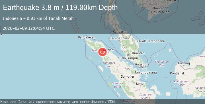
Earthquake Northern Sumatra, Indonesia
Mon, 09 Feb 2026 12:04:55 GMT
Time1 hour ago
Location
3.6486, 97.8439
Depth
113.1 KM
Event Summary
A 3.6 magnitude earthquake struck on Northern Sumatra, Indonesia, at Mon, 09 Feb 2026 12:04:55 GMT. Depth: 113.124687km. Reviewed by BMKG seismologists, this minor quake occurred at a magnitude type of M.
Magnitude
3.6
M
Source
BMKG
Intensity
-
Agency Reports
1 Sources| Source | Magnitude | Depth | Time |
|---|---|---|---|
| BMKGPrimary | 3.6 | 113 km | 1 hour ago |
Earthquake Details
AutomaticEvent IDbmg2026cuen
Tsunami PotentialNo
Magnitude TypeM
Nearest Places
- Deleng Bulubiang2.3 km
- Gunung Pungongesong2.4 km
- Gampong Lawe Sekerah2.7 km
- Gunung Buluhbiang4.4 km
- Deleng Natam4.7 km
Comments
Join the discussion about this event.
Latest Earthquakes
3.5Mag
West Papua, Indonesia
Time1 hour ago
Depth10.00 km
SourceBMKG (Automatic)
0.5Mag
23 km N of Ridgecrest, CA
Time1 hour ago
Depth5.03 km
SourceUSGS (Automatic)
2.2Mag
FRANCE
Time1 hour ago
Depth5.00 km
SourceReNaSS (Automatic)
2.5Mag
10 km N of Girdwood, Alaska
Time1 hour ago
Depth21.00 km
SourceUSGS (Automatic)
2.3Mag
Sumbawa Region, Indonesia
Time1 hour ago
Depth71.13 km
SourceBMKG (Automatic)
Nearby Earthquakes
2.6Mag
Northern Sumatra, Indonesia
Time5 days ago
Depth105.82 km
SourceBMKG (Automatic)
2.4Mag
Northern Sumatra, Indonesia
Time2 days ago
Depth67.73 km
SourceBMKG (Automatic)
2.9Mag
Northern Sumatra, Indonesia
Time1 week ago
Depth10.00 km
SourceBMKG (Automatic)
4.3Mag
Northern Sumatra, Indonesia
Time2 weeks ago
Depth10.00 km
SourceBMKG (Automatic)
2.2Mag
Northern Sumatra, Indonesia
Time1 week ago
Depth2.19 km
SourceBMKG (Automatic)