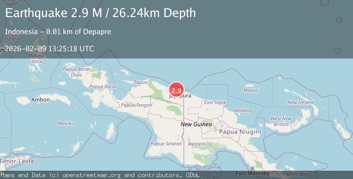
Earthquake Near North Coast of West Papua
Mon, 09 Feb 2026 13:25:19 GMT
Time1 hour ago
Location
-2.4964, 140.3530
Depth
23.5 KM
Event Summary
A 2.5 magnitude earthquake struck on Near North Coast of West Papua, at Mon, 09 Feb 2026 13:25:19 GMT. Depth: 23.473768km. Reviewed by BMKG seismologists, this minor quake occurred at a magnitude type of M.
Magnitude
2.5
M
Source
BMKG
Intensity
-
Agency Reports
1 Sources| Source | Magnitude | Depth | Time |
|---|---|---|---|
| BMKGPrimary | 2.5 | 23 km | 1 hour ago |
Earthquake Details
AutomaticEvent IDbmg2026cuhe
Tsunami PotentialNo
Magnitude TypeM
Nearest Places
- Waibronbono0.8 km
- Paipou1.6 km
- Kampung Entiyebo1.6 km
- Kantome2.1 km
- Depapre2.3 km
Comments
Join the discussion about this event.
Latest Earthquakes
2.5Mag
Sumbawa Region, Indonesia
Time1 hour ago
Depth8.98 km
SourceBMKG (Automatic)
2.4Mag
OKLAHOMA
Time1 hour ago
Depth2.90 km
SourceOK (Automatic)
0.7Mag
2 km NNE of The Geysers, CA
Time1 hour ago
Depth1.77 km
SourceUSGS (Automatic)
4.4Mag
Java, Indonesia
Time1 hour ago
Depth10.00 km
SourceBMKG (Automatic)
0.8Mag
SLOVENIA
Time1 hour ago
Depth0.00 km
SourceOGS (Automatic)
Nearby Earthquakes
2.1Mag
Near North Coast of West Papua
Time2 weeks ago
Depth10.56 km
SourceBMKG (Automatic)
2.2Mag
Near North Coast of West Papua
Time1 week ago
Depth10.00 km
SourceBMKG (Automatic)
2.6Mag
Near North Coast of West Papua
Time1 day ago
Depth10.00 km
SourceBMKG (Automatic)
2.0Mag
Near North Coast of West Papua
Time3 days ago
Depth22.07 km
SourceBMKG (Automatic)
2.5Mag
Near North Coast of West Papua
Time1 week ago
Depth11.29 km
SourceBMKG (Automatic)