Earthquake Bali Sea
Mon, 09 Feb 2026 22:03:47 GMT
Time1 hour ago
Location
-7.8406, 117.5037
Depth
237.9 KM
Event Summary
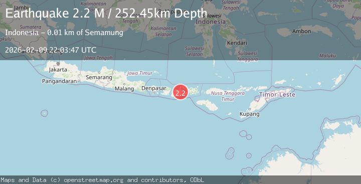
A 2.2 magnitude earthquake struck on Bali Sea, at Mon, 09 Feb 2026 22:03:47 GMT. Depth: 237.907776km. Reviewed by BMKG seismologists, this minor quake occurred at a magnitude type of M.
Magnitude
2.2
M
Source
BMKG
Intensity
-
Agency Reports
1 Sources| Source | Magnitude | Depth | Time |
|---|---|---|---|
| BMKGPrimary | 2.2 | 238 km | 1 hour ago |
Earthquake Details
AutomaticEvent IDbmg2026cuyh
Tsunami PotentialNo
Magnitude TypeM
Nearest Places
- Pulau Sailus Kecil29.3 km
- Desa Poleonro29.4 km
- Tanjung Timor33.3 km
- Pulau Sadapur34.0 km
- Gosong Sakunci34.4 km
Comments
Join the discussion about this event.
Latest Earthquakes
1.6Mag
3 km E of San Ramon, CA
Time1 hour ago
Depth4.85 km
SourceUSGS (Automatic)
3.9Mag
Banda Sea
Time2 hours ago
Depth191.34 km
SourceBMKG (Automatic)
1.1Mag
5 km NNW of Rancho Cucamonga, CA
Time2 hours ago
Depth12.52 km
SourceUSGS (Automatic)
1.9Mag
4 km SW of Tahoe Vista, CA
Time2 hours ago
Depth3.91 km
SourceUSGS (Automatic)
1.6Mag
13 km W of Point Possession, Alaska
Time2 hours ago
Depth7.70 km
SourceUSGS (Automatic)
Nearby Earthquakes
2.5Mag
Bali Sea
Time1 week ago
Depth22.43 km
SourceBMKG (Automatic)
2.2Mag
Bali Sea
Time6 days ago
Depth13.52 km
SourceBMKG (Automatic)
2.1Mag
Bali Sea
Time6 days ago
Depth10.00 km
SourceBMKG (Automatic)
2.3Mag
Bali Sea
Time1 week ago
Depth10.00 km
SourceBMKG (Automatic)
2.3Mag
Bali Sea
Time2 weeks ago
Depth10.00 km
SourceBMKG (Automatic)