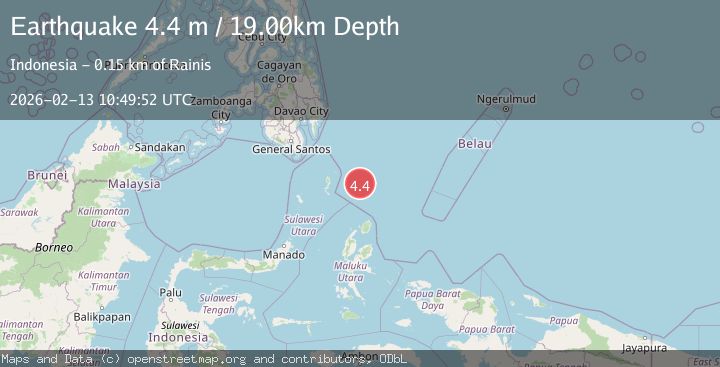
Earthquake North of Halmahera, Indonesia
Fri, 13 Feb 2026 10:49:52 GMT
Time4 days ago
Location
4.2412, 128.2290
Depth
19.5 KM
Event Summary
A 4.4 magnitude earthquake struck on North of Halmahera, Indonesia, at Fri, 13 Feb 2026 10:49:52 GMT. Depth: 19.483393km. Reviewed by BMKG seismologists, this light quake occurred at a magnitude type of M.
Magnitude
4.4
M
Source
BMKG
Intensity
-
Agency Reports
1 Sources| Source | Magnitude | Depth | Time |
|---|---|---|---|
| BMKGPrimary | 4.4 | 19 km | 4 days ago |
Earthquake Details
ManualEvent IDbmg2026dbkb
Tsunami PotentialNo
Magnitude TypeM
Nearest Places
- Snellius Ridge36.9 km
- Talaud Trough94.0 km
- Pulau Kakorotan126.1 km
- Desa Kakorotan126.1 km
- Pulau Intata126.8 km
Comments
Join the discussion about this event.
Latest Earthquakes
2.1Mag
Tarapaca, Chile
Time4 minutes ago
Depth8.18 km
SourceVYT (Automatic)
1.4Mag
12 km ESE of Olancha, CA
Time4 minutes ago
Depth7.15 km
SourceUSGS (Automatic)
2.8Mag
northwestern Russia
Time5 minutes ago
Depth10.00 km
SourceVYT (Automatic)
3.3Mag
Near North Coast of West Papua
Time5 minutes ago
Depth10.00 km
SourceBMKG
1.2Mag
5 km NNE of Fishhook, Alaska
Time6 minutes ago
Depth0.80 km
SourceUSGS (Automatic)
Nearby Earthquakes
4.6Mag
North of Halmahera, Indonesia
Time4 days ago
Depth21.15 km
SourceBMKG
4.4Mag
north of Halmahera, Indonesia
Time2 days ago
Depth10.00 km
SourceVYT (Automatic)
4.1Mag
North of Halmahera, Indonesia
Time1 day ago
Depth10.00 km
SourceBMKG
4.7Mag
north of Halmahera, Indonesia
Time2 days ago
Depth10.00 km
SourceVYT (Automatic)
4.0Mag
North of Halmahera, Indonesia
Time4 days ago
Depth10.00 km
SourceBMKG