Earthquake North of Halmahera, Indonesia
Fri, 13 Feb 2026 13:12:22 GMT
Time4 days ago
Location
4.2424, 128.2650
Depth
21.1 KM
Event Summary
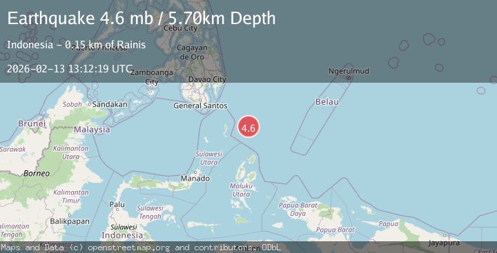
A 4.6 magnitude earthquake struck on North of Halmahera, Indonesia, at Fri, 13 Feb 2026 13:12:22 GMT. Depth: 21.149761km. Reviewed by BMKG seismologists, this light quake occurred at a magnitude type of M.
Magnitude
4.6
M
Source
BMKG
Intensity
-
Agency Reports
2 Sources| Source | Magnitude | Depth | Time |
|---|---|---|---|
| BMKGPrimary | 4.6 | 21 km | 4 days ago |
| EMSC | 4.6 | 6 km | 4 days ago |
Earthquake Details
ManualEvent IDbmg2026dbou
Tsunami PotentialNo
Magnitude TypeM
Nearest Places
- Snellius Ridge39.9 km
- Talaud Trough97.9 km
- Pulau Kakorotan129.8 km
- Desa Kakorotan129.8 km
- Pulau Intata130.5 km
Comments
Join the discussion about this event.
Latest Earthquakes
2.7Mag
SICILY, ITALY
Time15 hours ago
Depth5.00 km
SourceMLT (Automatic)
2.0Mag
Southern California
Time15 hours ago
Depth0.00 km
SourceVYT (Automatic)
1.4Mag
Southern Alaska
Time15 hours ago
Depth11.84 km
SourceVYT (Automatic)
2.1Mag
Tarapaca, Chile
Time15 hours ago
Depth30.27 km
SourceVYT (Automatic)
2.6Mag
COQUIMBO, CHILE
Time15 hours ago
Depth31.30 km
SourceCSN (Automatic)
Nearby Earthquakes
4.4Mag
North of Halmahera, Indonesia
Time5 days ago
Depth19.48 km
SourceBMKG
4.4Mag
north of Halmahera, Indonesia
Time2 days ago
Depth10.00 km
SourceVYT (Automatic)
4.7Mag
north of Halmahera, Indonesia
Time2 days ago
Depth10.00 km
SourceVYT (Automatic)
4.5Mag
North of Halmahera, Indonesia
Time4 days ago
Depth10.00 km
SourceBMKG
3.9Mag
North of Halmahera, Indonesia
Time4 days ago
Depth10.00 km
SourceBMKG