Earthquake north of Halmahera, Indonesia
Sun, 15 Feb 2026 15:58:19 GMT
Time2 days ago
Location
4.2977, 128.2828
Depth
10.0 KM
Event Summary
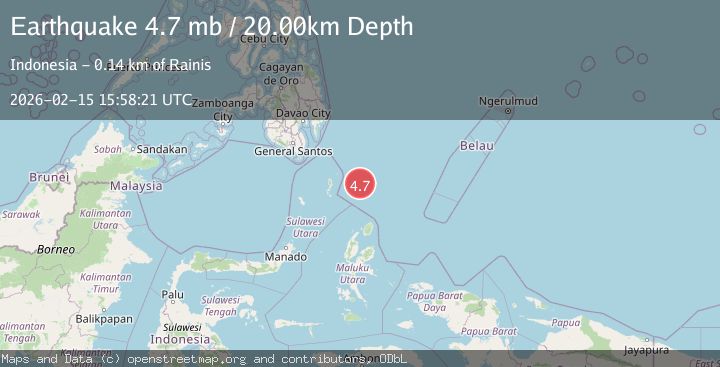
A 4.7 magnitude earthquake struck on north of Halmahera, Indonesia, at Sun, 15 Feb 2026 15:58:19 GMT. Depth: 10km. Reviewed by VYT seismologists, this light quake occurred at a magnitude type of earthquake.
Magnitude
4.7
earthquake
Source
VYT
Intensity
-
Agency Reports
3 Sources| Source | Magnitude | Depth | Time |
|---|---|---|---|
| VYTPrimary | 3.9 | 10 km | 2 days ago |
| BMKG | 4.7 | 5 km | 2 days ago |
| GFZ | 4.7 | 20 km | 2 days ago |
Earthquake Details
AutomaticEvent IDvyt_2r6u6jcg2e7op
Tsunami PotentialNo
Magnitude Typeearthquake
Nearest Places
- Snellius Ridge45.6 km
- Talaud Trough101.6 km
- Pulau Kakorotan129.8 km
- Desa Kakorotan129.8 km
- Pulau Intata130.4 km
Comments
Join the discussion about this event.
Latest Earthquakes
2.8Mag
Sulawesi, Indonesia
Time3 minutes ago
Depth21.08 km
SourceBMKG
2.1Mag
WESTERN TURKEY
Time7 minutes ago
Depth12.30 km
SourceKOERI (Automatic)
2.2Mag
Alaska Peninsula
Time7 minutes ago
Depth57.74 km
SourceVYT (Automatic)
3.8Mag
WESTERN TURKEY
Time10 minutes ago
Depth13.30 km
SourceKOERI (Automatic)
1.6Mag
27 km ESE of Balmorhea, Texas
Time10 minutes ago
Depth3.56 km
SourceUSGS (Automatic)
Nearby Earthquakes
4.4Mag
north of Halmahera, Indonesia
Time2 days ago
Depth10.00 km
SourceVYT (Automatic)
3.9Mag
NORTH OF HALMAHERA, INDONESIA
Time4 days ago
Depth25.00 km
SourceBMKG (Automatic)
4.5Mag
North of Halmahera, Indonesia
Time4 days ago
Depth10.00 km
SourceBMKG
3.2Mag
north of Halmahera, Indonesia
Time2 days ago
Depth10.00 km
SourceVYT (Automatic)
4.6Mag
North of Halmahera, Indonesia
Time4 days ago
Depth21.15 km
SourceBMKG