Earthquake Northern Sumatra, Indonesia
Fri, 13 Feb 2026 20:26:26 GMT
Time5 days ago
Location
4.1636, 97.3990
Depth
0.0 KM
Event Summary
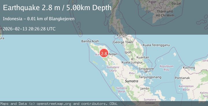
A 2.8 magnitude earthquake struck on Northern Sumatra, Indonesia, at Fri, 13 Feb 2026 20:26:26 GMT. Depth: 0km. Reviewed by BMKG seismologists, this minor quake occurred at a magnitude type of M.
Magnitude
2.8
M
Source
BMKG
Intensity
-
Agency Reports
1 Sources| Source | Magnitude | Depth | Time |
|---|---|---|---|
| BMKGPrimary | 2.8 | 5 km | 5 days ago |
Earthquake Details
ManualEvent IDbmg2026dcdc
Tsunami PotentialNo
Magnitude TypeM
Nearest Places
- Burni Pepelar0.5 km
- Van Daalen Mountains1.8 km
- Burni Siluman2.5 km
- Burni Ujemulu2.8 km
- Burni Apitan3.2 km
Comments
Join the discussion about this event.
Latest Earthquakes
3.4Mag
San Juan, Argentina
Time5 minutes ago
Depth10.00 km
SourceVYT (Automatic)
3.0Mag
Potosi, Bolivia
Time7 minutes ago
Depth269.04 km
SourceVYT (Automatic)
2.4Mag
Central Alaska
Time10 minutes ago
Depth0.24 km
SourceVYT (Automatic)
3.7Mag
Seram, Indonesia
Time10 minutes ago
Depth0.00 km
SourceVYT (Automatic)
3.9Mag
North of Halmahera, Indonesia
Time11 minutes ago
Depth14.71 km
SourceBMKG
Nearby Earthquakes
2.0Mag
Northern Sumatra, Indonesia
Time3 days ago
Depth5.00 km
SourceBMKG
3.0Mag
Northern Sumatra, Indonesia
Time2 weeks ago
Depth5.00 km
SourceBMKG (Automatic)
2.9Mag
Northern Sumatra, Indonesia
Time1 week ago
Depth1.00 km
SourceBMKG (Automatic)
2.1Mag
Northern Sumatra, Indonesia
Time6 hours ago
Depth3.27 km
SourceBMKG
2.9Mag
Northern Sumatra, Indonesia
Time1 week ago
Depth3.00 km
SourceBMKG (Automatic)