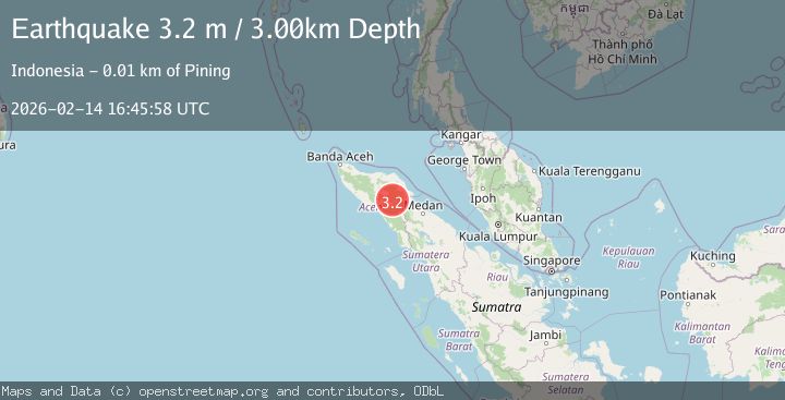
Earthquake Northern Sumatra, Indonesia
Sat, 14 Feb 2026 16:45:58 GMT
Time3 days ago
Location
4.1373, 97.4586
Depth
3.0 KM
Event Summary
A 3.2 magnitude earthquake struck on Northern Sumatra, Indonesia, at Sat, 14 Feb 2026 16:45:58 GMT. Depth: 3km. Reviewed by BMKG seismologists, this minor quake occurred at a magnitude type of M.
Magnitude
3.2
M
Source
BMKG
Intensity
-
Agency Reports
2 Sources| Source | Magnitude | Depth | Time |
|---|---|---|---|
| BMKGPrimary | 3.2 | 3 km | 3 days ago |
| VYT | 3.0 | 1 km | 3 days ago |
Earthquake Details
ManualEvent IDbmg2026ddri
Tsunami PotentialNo
Magnitude TypeM
Nearest Places
- Gunung Aber4.1 km
- Aer Putih4.2 km
- Burni Siluman4.7 km
- Gampong Gajah5.0 km
- Burni Apitan5.4 km
Comments
Join the discussion about this event.
Latest Earthquakes
2.8Mag
Sunda Strait, Indonesia
Time4 minutes ago
Depth3.61 km
SourceBMKG
3.6Mag
south of Alaska
Time5 minutes ago
Depth10.00 km
SourceVYT (Automatic)
1.2Mag
Central Alaska
Time7 minutes ago
Depth68.97 km
SourceVYT (Automatic)
1.2Mag
Washington
Time9 minutes ago
Depth0.00 km
SourceVYT (Automatic)
0.8Mag
10 km WNW of The Geysers, CA
Time15 minutes ago
Depth1.96 km
SourceUSGS (Automatic)
Nearby Earthquakes
4.0Mag
northern Sumatra, Indonesia
Time5 days ago
Depth0.00 km
SourceVYT (Automatic)
2.4Mag
Northern Sumatra, Indonesia
Time1 week ago
Depth5.00 km
SourceBMKG (Automatic)
2.8Mag
Northern Sumatra, Indonesia
Time3 weeks ago
Depth5.00 km
SourceBMKG (Automatic)
3.0Mag
NORTHERN SUMATRA, INDONESIA
Time0 months ago
Depth3.00 km
SourceBMKG (Automatic)
2.6Mag
Northern Sumatra, Indonesia
Time2 weeks ago
Depth5.00 km
SourceBMKG (Automatic)