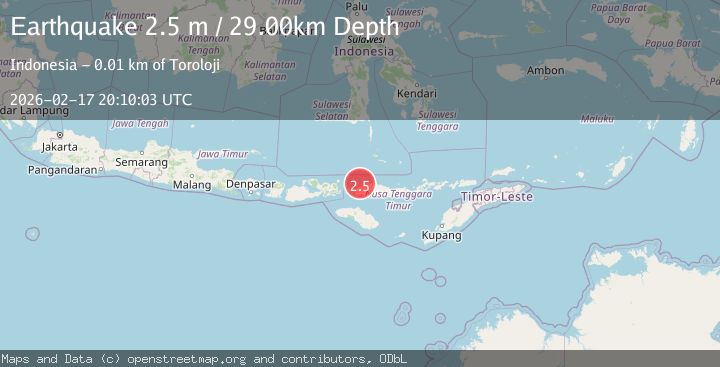
Earthquake Flores Region, Indonesia
Tue, 17 Feb 2026 20:10:03 GMT
Time14 hours ago
Location
-8.3465, 120.0658
Depth
28.8 KM
Event Summary
A 2.2 magnitude earthquake struck on Flores Region, Indonesia, at Tue, 17 Feb 2026 20:10:03 GMT. Depth: 28.776529km. Reviewed by BMKG seismologists, this minor quake occurred at a magnitude type of M.
Magnitude
2.2
M
Source
BMKG
Intensity
-
Agency Reports
1 Sources| Source | Magnitude | Depth | Time |
|---|---|---|---|
| BMKGPrimary | 2.2 | 29 km | 14 hours ago |
Earthquake Details
ManualEvent IDbmg2026djko
Tsunami PotentialNo
Magnitude TypeM
Nearest Places
- Saka Sari3.0 km
- Toro Lehok Camba3.5 km
- Tanjung Lohokcambaah3.6 km
- Teluk Bangkau3.6 km
- Pasirpanjang3.9 km
Comments
Join the discussion about this event.
Latest Earthquakes
1.8Mag
Antofagasta, Chile
Time14 hours ago
Depth32.10 km
SourceVYT (Automatic)
1.4Mag
FRANCE
Time14 hours ago
Depth2.40 km
SourceETHZ (Automatic)
2.4Mag
Minahassa Peninsula, Sulawesi
Time14 hours ago
Depth7.56 km
SourceBMKG
2.7Mag
Halmahera, Indonesia
Time14 hours ago
Depth58.00 km
SourceBMKG
2.1Mag
Sumbawa Region, Indonesia
Time14 hours ago
Depth13.19 km
SourceBMKG
Nearby Earthquakes
2.7Mag
Flores Region, Indonesia
Time1 week ago
Depth169.17 km
SourceBMKG (Automatic)
2.5Mag
FLORES REGION, INDONESIA
Time1 month ago
Depth166.00 km
SourceBMKG (Automatic)
2.6Mag
FLORES REGION, INDONESIA
Time1 month ago
Depth25.00 km
SourceBMKG (Automatic)
3.0Mag
FLORES REGION, INDONESIA
Time1 year ago
Depth176.00 km
SourceBMKG (Automatic)
2.6Mag
FLORES REGION, INDONESIA
Time1 month ago
Depth168.00 km
SourceBMKG (Automatic)