Earthquake Northern Sumatra, Indonesia
Tue, 24 Feb 2026 23:57:38 GMT
Time1 hour ago
Location
4.1496, 97.4067
Depth
0.8 KM
Event Summary
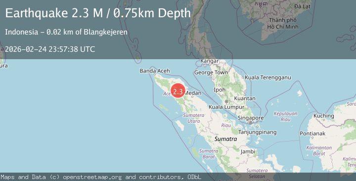
A 2.3 magnitude earthquake struck on Northern Sumatra, Indonesia, at Tue, 24 Feb 2026 23:57:38 GMT. Depth: 0.753891km. Reviewed by BMKG seismologists, this minor quake occurred at a magnitude type of M.
Magnitude
2.3
M
Source
BMKG
Intensity
-
Agency Reports
1 Sources| Source | Magnitude | Depth | Time |
|---|---|---|---|
| BMKGPrimary | 2.3 | 1 km | 1 hour ago |
Earthquake Details
ManualEvent IDbmg2026dwmp
Tsunami PotentialNo
Magnitude TypeM
Nearest Places
- 1.3 km
- 1.4 km
- 1.4 km
- 3.2 km
- 4.3 km
Comments
Join the discussion about this event.
Latest Earthquakes
1.2Mag
7 km ENE of Fox, Alaska
Time1 hour ago
Depth5.00 km
SourceUSGS (Automatic)
3.2Mag
Salta, Argentina
Time1 hour ago
Depth241.58 km
SourceVYT (Automatic)
1.7Mag
24 km ESE of Naalehu, Hawaii
Time1 hour ago
Depth32.31 km
SourceUSGS (Automatic)
1.3Mag
NORTHERN ITALY
Time1 hour ago
Depth8.00 km
SourceOGS (Automatic)
3.1Mag
Halmahera, Indonesia
Time1 hour ago
Depth16.99 km
SourceBMKG
Nearby Earthquakes
2.0Mag
Northern Sumatra, Indonesia
Time1 week ago
Depth5.00 km
SourceBMKG
2.9Mag
Northern Sumatra, Indonesia
Time2 weeks ago
Depth3.00 km
SourceBMKG (Automatic)
2.8Mag
Northern Sumatra, Indonesia
Time1 week ago
Depth0.00 km
SourceBMKG
2.9Mag
Northern Sumatra, Indonesia
Time2 weeks ago
Depth1.00 km
SourceBMKG (Automatic)
2.1Mag
Northern Sumatra, Indonesia
Time6 days ago
Depth3.27 km
SourceBMKG