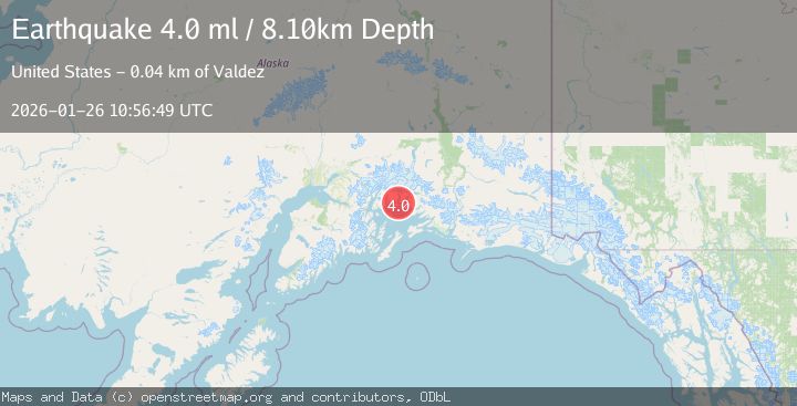
Earthquake SOUTHERN ALASKA
Mon, 26 Jan 2026 10:56:48 GMT
Time21 hours ago
Location
60.9610, -147.0150
Depth
26.9 KM
Event Summary
A 4.0 magnitude earthquake struck on SOUTHERN ALASKA, at Mon, 26 Jan 2026 10:56:48 GMT. Depth: 26.9km. Reviewed by AK seismologists, this light quake occurred at a magnitude type of ml.
Magnitude
4.0
ml
Source
AK
Intensity
-
Agency Reports
1 Sources| Source | Magnitude | Depth | Time |
|---|---|---|---|
| AKPrimary | 4.0 | 27 km | 21 hours ago |
Earthquake Details
AutomaticEvent IDemsc_AK_20260126_0000184
Tsunami PotentialNo
Magnitude Typeml
Nearest Places
- Emerald Cove1.2 km
- Round Mountain1.8 km
- Heather Island2.0 km
- Lutris Pass2.3 km
- Jade Harbor2.4 km
Comments
Join the discussion about this event.
Latest Earthquakes
1.3Mag
11 km N of Piru, CA
Time22 hours ago
Depth6.34 km
SourceUSGS (Automatic)
4.4Mag
SOUTHWESTERN RYUKYU ISL., JAPAN
Time22 hours ago
Depth50.00 km
SourceJMA (Automatic)
1.1Mag
6 km NNE of Banning, CA
Time22 hours ago
Depth8.23 km
SourceUSGS (Automatic)
2.4Mag
FRANCE
Time22 hours ago
Depth0.00 km
SourceReNaSS (Automatic)
2.3Mag
22 km W of Petrolia, CA
Time22 hours ago
Depth11.53 km
SourceUSGS (Automatic)
Nearby Earthquakes
3.2Mag
22 km WNW of Tatitlek, Alaska
Time4 days ago
Depth18.30 km
SourceUSGS (Automatic)
1.3Mag
47 km WNW of Tatitlek, Alaska
Time3 days ago
Depth5.00 km
SourceUSGS (Automatic)
2.3Mag
12 km WSW of Valdez, Alaska
Time2 days ago
Depth49.60 km
SourceUSGS (Automatic)
1.5Mag
52 km WNW of Tatitlek, Alaska
Time4 days ago
Depth7.30 km
SourceUSGS (Automatic)
1.2Mag
19 km S of Tatitlek, Alaska
Time1 day ago
Depth26.20 km
SourceUSGS (Automatic)