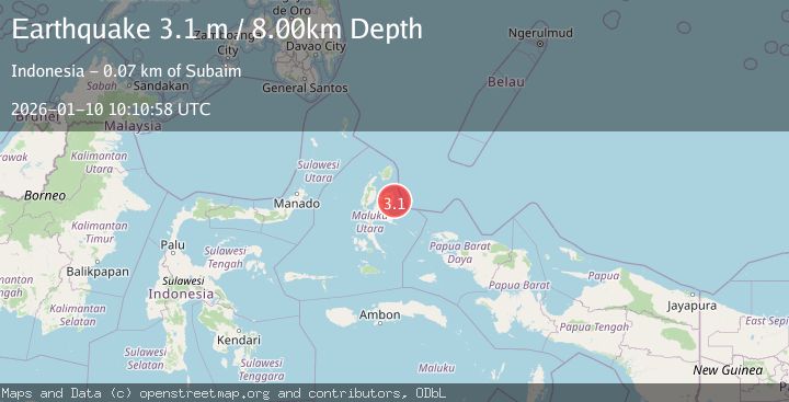
Earthquake HALMAHERA, INDONESIA
Sat, 10 Jan 2026 10:10:58 GMT
Time1 month ago
Location
1.2300, 128.7900
Depth
8.0 KM
Event Summary
A 3.1 magnitude earthquake struck on HALMAHERA, INDONESIA, at Sat, 10 Jan 2026 10:10:58 GMT. Depth: 8km. Reviewed by BMKG seismologists, this minor quake occurred at a magnitude type of m.
Magnitude
3.1
m
Source
BMKG
Intensity
-
Agency Reports
1 Sources| Source | Magnitude | Depth | Time |
|---|---|---|---|
| BMKGPrimary | 3.1 | 8 km | 1 month ago |
Earthquake Details
AutomaticEvent IDemsc_BMKG_20260110_0000121
Tsunami PotentialNo
Magnitude Typem
Nearest Places
- Tanjung Lili8.2 km
- Teluk Lolosita9.5 km
- Sungai Ake Lili9.9 km
- Teluk Lili9.9 km
- Tanjung Lemo10.4 km
Comments
Join the discussion about this event.
Latest Earthquakes
1.5Mag
Southern Alaska
Time21 hours ago
Depth67.26 km
SourceVYT (Automatic)
2.4Mag
Northern Sumatra, Indonesia
Time21 hours ago
Depth12.76 km
SourceBMKG
1.2Mag
10 km NW of The Geysers, CA
Time21 hours ago
Depth1.41 km
SourceUSGS (Automatic)
1.0Mag
Southern Alaska
Time21 hours ago
Depth14.53 km
SourceVYT (Automatic)
3.5Mag
Kepulauan Mentawai region, Indonesia
Time21 hours ago
Depth29.42 km
SourceVYT (Automatic)
Nearby Earthquakes
3.0Mag
HALMAHERA, INDONESIA
Time2 years ago
Depth10.00 km
SourceDJA (Automatic)
3.0Mag
HALMAHERA, INDONESIA
Time1 year ago
Depth10.00 km
SourceBMKG (Automatic)
2.7Mag
Halmahera, Indonesia
Time3 weeks ago
Depth5.18 km
SourceBMKG (Automatic)
4.0Mag
HALMAHERA, INDONESIA
Time3 years ago
Depth10.00 km
SourceDJA (Automatic)
3.0Mag
HALMAHERA, INDONESIA
Time1 year ago
Depth25.00 km
SourceBMKG (Automatic)