Earthquake MORO GULF, MINDANAO, PHILIPPINES
Mon, 02 Feb 2026 09:58:21 GMT
Time3 weeks ago
Location
6.5900, 123.6100
Depth
5.0 KM
Event Summary
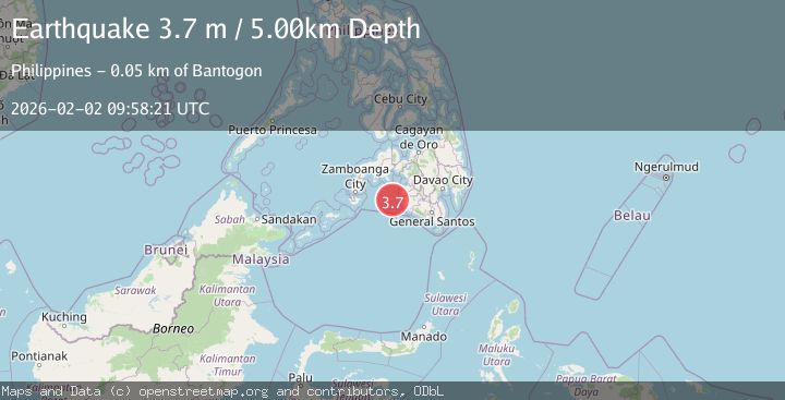
A 3.7 magnitude earthquake struck on MORO GULF, MINDANAO, PHILIPPINES, at Mon, 02 Feb 2026 09:58:21 GMT. Depth: 5km. Reviewed by PIVS seismologists, this minor quake occurred at a magnitude type of m.
Magnitude
3.7
m
Source
PIVS
Intensity
-
Agency Reports
1 Sources| Source | Magnitude | Depth | Time |
|---|---|---|---|
| PIVSPrimary | 3.7 | 5 km | 3 weeks ago |
Earthquake Details
AutomaticEvent IDemsc_PIVS_20260202_0000153
Tsunami PotentialNo
Magnitude Typem
Nearest Places
- 41.3 km
- 42.1 km
- 44.7 km
- 44.7 km
- 45.0 km
Comments
Join the discussion about this event.
Latest Earthquakes
1.4Mag
Southern Alaska
Time12 hours ago
Depth58.84 km
SourceVYT (Automatic)
2.1Mag
Central Alaska
Time12 hours ago
Depth0.00 km
SourceVYT (Automatic)
2.7Mag
Timor region, Indonesia
Time12 hours ago
Depth0.00 km
SourceVYT (Automatic)
1.3Mag
13 km ENE of Borrego Springs, CA
Time12 hours ago
Depth10.74 km
SourceUSGS (Automatic)
1.9Mag
10 km ENE of Pāhala, Hawaii
Time12 hours ago
Depth32.05 km
SourceUSGS (Automatic)
Nearby Earthquakes
5.6Mag
MORO GULF, MINDANAO, PHILIPPINES
Time3 weeks ago
Depth1.00 km
SourcePIVS (Automatic)
3.2Mag
MORO GULF, MINDANAO, PHILIPPINES
Time3 weeks ago
Depth4.00 km
SourcePIVS (Automatic)
5.1Mag
MORO GULF, MINDANAO, PHILIPPINES
Time3 weeks ago
Depth7.00 km
SourcePIVS (Automatic)
3.7Mag
MORO GULF, MINDANAO, PHILIPPINES
Time3 weeks ago
Depth2.00 km
SourcePIVS (Automatic)
4.9Mag
MORO GULF, MINDANAO, PHILIPPINES
Time3 weeks ago
Depth4.00 km
SourcePIVS (Automatic)