Earthquake MORO GULF, MINDANAO, PHILIPPINES
Wed, 04 Feb 2026 12:27:20 GMT
Time16 hours ago
Location
6.3900, 123.7700
Depth
17.0 KM
Event Summary
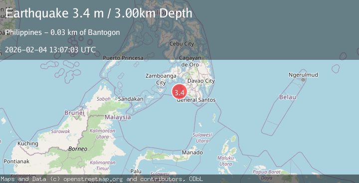
A 3.1 magnitude earthquake struck on MORO GULF, MINDANAO, PHILIPPINES, at Wed, 04 Feb 2026 12:27:20 GMT. Depth: 17km. Reviewed by PIVS seismologists, this minor quake occurred at a magnitude type of m.
Magnitude
3.1
m
Source
PIVS
Intensity
-
Agency Reports
1 Sources| Source | Magnitude | Depth | Time |
|---|---|---|---|
| PIVSPrimary | 3.1 | 17 km | 16 hours ago |
Earthquake Details
AutomaticEvent IDemsc_PIVS_20260204_0000177
Tsunami PotentialNo
Magnitude Typem
Nearest Places
- Donaung Shoals28.2 km
- Donauang Island28.9 km
- Sangay Point29.7 km
- Danawan Point29.8 km
- Basiauang Bay29.8 km
Comments
Join the discussion about this event.
Latest Earthquakes
2.4Mag
Sumbawa Region, Indonesia
Time16 hours ago
Depth17.33 km
SourceBMKG (Automatic)
0.8Mag
7 km WNW of The Geysers, CA
Time16 hours ago
Depth12.69 km
SourceUSGS (Automatic)
2.4Mag
FRANCE
Time16 hours ago
Depth5.00 km
SourceReNaSS (Automatic)
2.3Mag
Southern Sumatra, Indonesia
Time16 hours ago
Depth15.95 km
SourceBMKG (Automatic)
1.8Mag
10 km ESE of Pearsall, Texas
Time16 hours ago
Depth9.85 km
SourceUSGS (Automatic)
Nearby Earthquakes
5.4Mag
Mindanao, Philippines
Time1 week ago
Depth10.00 km
SourceBMKG (Automatic)
3.2Mag
MORO GULF, MINDANAO, PHILIPPINES
Time1 week ago
Depth1.00 km
SourcePIVS (Automatic)
3.6Mag
MORO GULF, MINDANAO, PHILIPPINES
Time4 days ago
Depth6.00 km
SourcePIVS (Automatic)
3.0Mag
MORO GULF, MINDANAO, PHILIPPINES
Time1 week ago
Depth23.00 km
SourcePIVS (Automatic)
5.0Mag
Mindanao, Philippines
Time1 week ago
Depth10.00 km
SourceBMKG (Automatic)