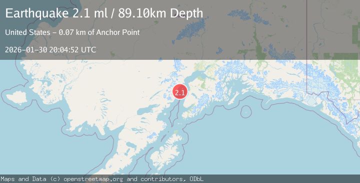
Earthquake 62 km WSW of Anchor Point, Alaska
Fri, 30 Jan 2026 19:51:41 GMT
Time13 hours ago
Location
59.6430, -152.9180
Depth
91.2 KM
Event Summary
A 2.2 magnitude earthquake struck on 62 km WSW of Anchor Point, Alaska, at Fri, 30 Jan 2026 19:51:41 GMT. Depth: 91.2km. Reviewed by USGS seismologists, this minor quake occurred at a magnitude type of ml.
Magnitude
2.2
ml
Source
USGS
Intensity
-
Agency Reports
1 Sources| Source | Magnitude | Depth | Time |
|---|---|---|---|
| USGSPrimary | 2.2 | 91 km | 13 hours ago |
Earthquake Details
ConfirmedEvent IDusgs_ak2026cctokl
Tsunami PotentialNo
Magnitude Typeml
Nearest Places
- Chinitna Point9.4 km
- Bow Creek10.0 km
- Brown Creek12.8 km
- Dry Bay12.8 km
- Knub Hill14.5 km
Comments
Join the discussion about this event.
Latest Earthquakes
2.1Mag
West Papua, Indonesia
Time13 hours ago
Depth65.29 km
SourceBMKG (Automatic)
2.2Mag
Sunda Strait, Indonesia
Time13 hours ago
Depth6.74 km
SourceBMKG (Automatic)
3.1Mag
Minahassa Peninsula, Sulawesi
Time13 hours ago
Depth10.00 km
SourceBMKG (Automatic)
1.7Mag
14 km WSW of Mojave, CA
Time13 hours ago
Depth7.99 km
SourceUSGS (Automatic)
2.7Mag
OFFSHORE TARAPACA, CHILE
Time13 hours ago
Depth53.20 km
SourceCSN (Automatic)
Nearby Earthquakes
2.0Mag
66 km ESE of Pedro Bay, Alaska
Time1 week ago
Depth95.00 km
SourceUSGS (Automatic)
2.6Mag
59 km W of Anchor Point, Alaska
Time5 days ago
Depth84.90 km
SourceUSGS (Automatic)
1.5Mag
53 km E of Pedro Bay, Alaska
Time1 week ago
Depth120.40 km
SourceUSGS (Automatic)
2.4Mag
51 km E of Pedro Bay, Alaska
Time6 days ago
Depth121.10 km
SourceUSGS (Automatic)
2.2Mag
61 km W of Anchor Point, Alaska
Time4 days ago
Depth97.80 km
SourceUSGS (Automatic)