Earthquake 88 km WNW of Yakutat, Alaska
Wed, 04 Feb 2026 02:21:03 GMT
Time12 hours ago
Location
59.9610, -141.0660
Depth
19.8 KM
Event Summary
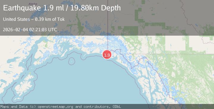
A 1.9 magnitude earthquake struck on 88 km WNW of Yakutat, Alaska, at Wed, 04 Feb 2026 02:21:03 GMT. Depth: 19.8km. Reviewed by USGS seismologists, this minor quake occurred at a magnitude type of ml.
Magnitude
1.9
ml
Source
USGS
Intensity
-
Agency Reports
1 Sources| Source | Magnitude | Depth | Time |
|---|---|---|---|
| USGSPrimary | 1.9 | 20 km | 12 hours ago |
Earthquake Details
AutomaticEvent IDusgs_ak2026ckpjmj
Tsunami PotentialNo
Magnitude Typeml
Nearest Places
- Lake Caetani8.7 km
- Chaix Hills11.1 km
- Caetani River11.5 km
- Crater Lake11.8 km
- Moore Nunatak16.0 km
Comments
Join the discussion about this event.
Latest Earthquakes
0.6Mag
SWITZERLAND
Time8 hours ago
Depth1.60 km
SourceETHZ (Automatic)
2.5Mag
Sumba Region, Indonesia
Time9 hours ago
Depth61.17 km
SourceBMKG (Automatic)
1.9Mag
4 km SE of San Ramon, CA
Time9 hours ago
Depth8.44 km
SourceUSGS (Automatic)
3.0Mag
WESTERN AUSTRALIA
Time9 hours ago
Depth10.00 km
SourceAUST (Automatic)
3.5Mag
SOUTH ISLAND OF NEW ZEALAND
Time9 hours ago
Depth36.80 km
SourceGNS (Automatic)
Nearby Earthquakes
1.6Mag
94 km WNW of Yakutat, Alaska
Time3 days ago
Depth22.60 km
SourceUSGS (Automatic)
2.6Mag
96 km WNW of Yakutat, Alaska
Time1 week ago
Depth4.10 km
SourceUSGS (Automatic)
1.9Mag
88 km NW of Yakutat, Alaska
Time4 days ago
Depth17.80 km
SourceUSGS (Automatic)
3.5Mag
SOUTHERN ALASKA
Time6 days ago
Depth21.80 km
SourceAK (Automatic)
3.2Mag
SOUTHEASTERN ALASKA
Time1 week ago
Depth6.70 km
SourceAK (Automatic)