Earthquake 100 km N of Yakutat, Alaska
Sat, 07 Feb 2026 02:03:05 GMT
Time1 hour ago
Location
60.4420, -139.4770
Depth
1.0 KM
Event Summary
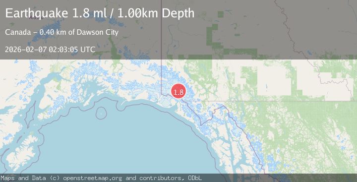
A 1.8 magnitude earthquake struck on 100 km N of Yakutat, Alaska, at Sat, 07 Feb 2026 02:03:05 GMT. Depth: 1km. Reviewed by USGS seismologists, this minor quake occurred at a magnitude type of ml.
Magnitude
1.8
ml
Source
USGS
Intensity
-
Agency Reports
1 Sources| Source | Magnitude | Depth | Time |
|---|---|---|---|
| USGSPrimary | 1.8 | 1 km | 1 hour ago |
Earthquake Details
ConfirmedEvent IDusgs_ak2026cqbyqd
Tsunami PotentialNo
Magnitude Typeml
Nearest Places
- St. Elias Mountains11.9 km
- Hubbard Glacier12.2 km
- Mount Vancouver15.3 km
- Hubbard Glacier15.4 km
- Mount King George19.7 km
Comments
Join the discussion about this event.
Latest Earthquakes
2.2Mag
SPAIN
Time8 minutes ago
Depth3.90 km
SourceIGN (Automatic)
3.3Mag
HOKKAIDO, JAPAN REGION
Time18 minutes ago
Depth0.00 km
SourceJMA (Automatic)
1.8Mag
14 km W of Petrolia, CA
Time22 minutes ago
Depth12.39 km
SourceUSGS (Automatic)
2.3Mag
PORTUGAL
Time23 minutes ago
Depth2.00 km
SourceIPMA (Automatic)
2.0Mag
47 km NNE of Chase, Alaska
Time25 minutes ago
Depth0.50 km
SourceUSGS (Automatic)
Nearby Earthquakes
3.5Mag
SOUTHERN YUKON TERRITORY, CANADA
Time1 week ago
Depth5.00 km
SourceNEIC (Automatic)
3.7Mag
SOUTHERN YUKON TERRITORY, CANADA
Time1 week ago
Depth5.00 km
SourceAK (Automatic)
3.7Mag
96 km N of Yakutat, Alaska
Time1 week ago
Depth5.00 km
SourceUSGS
3.6Mag
SOUTHERN YUKON TERRITORY, CANADA
Time5 days ago
Depth2.00 km
SourceAK (Automatic)
2.5Mag
SOUTHERN YUKON TERRITORY, CANADA
Time1 week ago
Depth5.90 km
SourceNEIC (Automatic)