Earthquake 5 km SE of San Ramon, CA
Mon, 02 Feb 2026 22:47:45 GMT
Time2 hours ago
Location
37.7530, -121.9393
Depth
6.5 KM
Event Summary
A 3.1 magnitude earthquake struck on 5 km SE of San Ramon, CA, at Mon, 02 Feb 2026 22:47:45 GMT. Depth: 6.46999979019165km. Reviewed by USGS seismologists, this minor quake occurred at a magnitude type of md.
Magnitude
3.1
md
Source
USGS
Intensity
-
Agency Reports
3 Sources| Source | Magnitude | Depth | Time |
|---|---|---|---|
| USGSPrimary | 3.1 | 8 km | 2 hours ago |
| NC | 3.1 | 8 km | 2 hours ago |
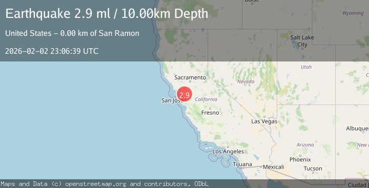
| NEIC | 2.9 | 10 km | 1 hour ago |
Earthquake Details
AutomaticEvent IDusgs_nc75306251
Tsunami PotentialNo
Magnitude Typemd
Nearest Places
- San Ramon Village Shopping Center0.2 km
- Coyote Creek0.7 km
- California High School0.9 km
- Montevideo Elementary School1.0 km
- City of San Ramon1.1 km
Comments
Join the discussion about this event.
Latest Earthquakes
1.7Mag
44 km NW of Tatitlek, Alaska
Time43 minutes ago
Depth5.00 km
SourceUSGS (Automatic)
2.1Mag
Sumbawa Region, Indonesia
Time44 minutes ago
Depth10.00 km
SourceBMKG (Automatic)
1.8Mag
4 km SE of San Ramon, CA
Time48 minutes ago
Depth6.96 km
SourceUSGS (Automatic)
3.3Mag
Java, Indonesia
Time50 minutes ago
Depth90.20 km
SourceBMKG (Automatic)
4.3Mag
TARAPACA, CHILE
Time50 minutes ago
Depth54.00 km
SourceCSLC (Automatic)
Nearby Earthquakes
2.5Mag
5 km SE of San Ramon, CA
Time3 hours ago
Depth6.55 km
SourceUSGS (Automatic)
3.4Mag
SAN FRANCISCO BAY AREA, CALIF.
Time3 days ago
Depth6.70 km
SourceNC (Automatic)
3.7Mag
SAN FRANCISCO BAY AREA, CALIF.
Time10 hours ago
Depth9.50 km
SourceNC (Automatic)
1.9Mag
4 km SE of San Ramon, CA
Time1 week ago
Depth8.30 km
SourceUSGS (Automatic)
3.8Mag
5 km SE of San Ramon, CA
Time9 hours ago
Depth8.67 km
SourceUSGS (Automatic)