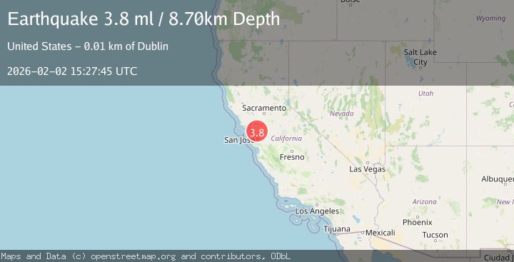
Earthquake 5 km SE of San Ramon, CA
Mon, 02 Feb 2026 15:27:45 GMT
Time2 hours ago
Location
37.7485, -121.9383
Depth
8.7 KM
Event Summary
A 3.8 magnitude earthquake struck on 5 km SE of San Ramon, CA, at Mon, 02 Feb 2026 15:27:45 GMT. Depth: 8.67000007629395km. Reviewed by USGS seismologists, this minor quake occurred at a magnitude type of ml.
Magnitude
3.8
ml
Source
USGS
Intensity
-
Agency Reports
1 Sources| Source | Magnitude | Depth | Time |
|---|---|---|---|
| USGSPrimary | 3.8 | 9 km | 2 hours ago |
Earthquake Details
AutomaticEvent IDusgs_nc75305826
Tsunami PotentialNo
Magnitude Typeml
Nearest Places
Comments
Join the discussion about this event.
Latest Earthquakes
3.5Mag
SHIKOKU, JAPAN
Time2 hours ago
Depth40.00 km
SourceJMA (Automatic)
1.5Mag
55 km S of Glacier View, Alaska
Time2 hours ago
Depth5.00 km
SourceUSGS (Automatic)
3.2Mag
Off West Coast of Northern Sumatra
Time2 hours ago
Depth10.00 km
SourceBMKG (Automatic)
2.2Mag
31 km E of Skwentna, Alaska
Time2 hours ago
Depth64.10 km
SourceUSGS (Automatic)
2.3Mag
Flores Region, Indonesia
Time2 hours ago
Depth38.94 km
SourceBMKG (Automatic)
Nearby Earthquakes
2.2Mag
SAN FRANCISCO BAY AREA, CALIF.
Time2 days ago
Depth8.70 km
SourceNC (Automatic)
3.4Mag
SAN FRANCISCO BAY AREA, CALIF.
Time2 days ago
Depth6.70 km
SourceNC (Automatic)
1.7Mag
5 km N of Dublin, CA
Time2 days ago
Depth7.61 km
SourceUSGS (Automatic)
1.9Mag
4 km SE of San Ramon, CA
Time1 week ago
Depth8.30 km
SourceUSGS (Automatic)
3.7Mag
SAN FRANCISCO BAY AREA, CALIF.
Time3 hours ago
Depth9.50 km
SourceNC (Automatic)