Earthquake Southern Alaska
Tue, 17 Feb 2026 04:08:23 GMT
Time1 day ago
Location
60.6104, -142.9353
Depth
18.9 KM
Event Summary
A 2.1 magnitude earthquake struck on Southern Alaska, at Tue, 17 Feb 2026 04:08:23 GMT. Depth: 18.9208984375km. Reviewed by VYT seismologists, this minor quake occurred at a magnitude type of earthquake.
Magnitude
2.1
earthquake
Source
VYT
Intensity
-
Agency Reports
2 Sources| Source | Magnitude | Depth | Time |
|---|---|---|---|
| VYTPrimary | 2.1 | 19 km | 1 day ago |
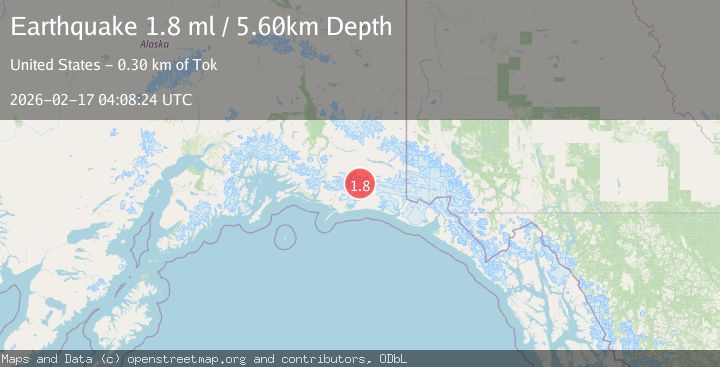
| USGS | 1.8 | 6 km | 1 day ago |
Earthquake Details
AutomaticEvent IDvyt_22eqx4bypf5uh
Tsunami PotentialNo
Magnitude Typeearthquake
Nearest Places
- Mount Steller13.6 km
- Waxell Ridge13.8 km
- Betge Glacier16.2 km
- Ovtsyn Glacier17.1 km
- Granite Creek21.4 km
Comments
Join the discussion about this event.
Latest Earthquakes
2.1Mag
Tarapaca, Chile
Time5 minutes ago
Depth8.18 km
SourceVYT (Automatic)
1.4Mag
12 km ESE of Olancha, CA
Time6 minutes ago
Depth7.15 km
SourceUSGS (Automatic)
2.8Mag
northwestern Russia
Time7 minutes ago
Depth10.00 km
SourceVYT (Automatic)
3.3Mag
Near North Coast of West Papua
Time7 minutes ago
Depth10.00 km
SourceBMKG
1.2Mag
5 km NNE of Fishhook, Alaska
Time8 minutes ago
Depth0.80 km
SourceUSGS (Automatic)
Nearby Earthquakes
2.7Mag
SOUTHERN ALASKA
Time1 month ago
Depth5.00 km
SourceNEIC (Automatic)
1.7Mag
91 km S of McCarthy, Alaska
Time2 weeks ago
Depth28.20 km
SourceUSGS (Automatic)
1.3Mag
Southern Alaska
Time1 day ago
Depth17.46 km
SourceVYT (Automatic)
1.4Mag
104 km S of McCarthy, Alaska
Time2 weeks ago
Depth6.30 km
SourceUSGS (Automatic)
1.8Mag
Southern Alaska
Time11 hours ago
Depth16.72 km
SourceVYT (Automatic)