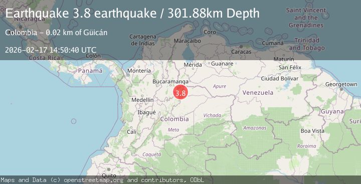
Earthquake northern Colombia
Tue, 17 Feb 2026 14:50:40 GMT
Time18 hours ago
Location
6.5566, -72.2321
Depth
301.9 KM
Event Summary
A 3.8 magnitude earthquake struck on northern Colombia, at Tue, 17 Feb 2026 14:50:40 GMT. Depth: 301.8798828125km. Reviewed by VYT seismologists, this minor quake occurred at a magnitude type of earthquake.
Magnitude
3.8
earthquake
Source
VYT
Intensity
-
Agency Reports
1 Sources| Source | Magnitude | Depth | Time |
|---|---|---|---|
| VYTPrimary | 3.8 | 302 km | 18 hours ago |
Earthquake Details
AutomaticEvent IDvyt_2xe6xcuy9inbs
Tsunami PotentialNo
Magnitude Typeearthquake
Nearest Places
- Carracas2.3 km
- Quebrada La Caja2.9 km
- Quebrada Hoya del Olvido3.4 km
- Rudiván3.6 km
- Peña del Aguila4.0 km
Comments
Join the discussion about this event.
Latest Earthquakes
1.5Mag
Southern Alaska
Time17 hours ago
Depth67.26 km
SourceVYT (Automatic)
2.4Mag
Northern Sumatra, Indonesia
Time17 hours ago
Depth12.76 km
SourceBMKG
1.2Mag
10 km NW of The Geysers, CA
Time17 hours ago
Depth1.41 km
SourceUSGS (Automatic)
1.0Mag
Southern Alaska
Time17 hours ago
Depth14.53 km
SourceVYT (Automatic)
3.5Mag
Kepulauan Mentawai region, Indonesia
Time17 hours ago
Depth29.42 km
SourceVYT (Automatic)
Nearby Earthquakes
5.0Mag
NORTHERN COLOMBIA
Time8 years ago
Depth30.00 km
SourceEMSC (Automatic)
3.6Mag
northern Colombia
Time5 days ago
Depth242.31 km
SourceVYT (Automatic)
2.8Mag
northern Colombia
Time6 days ago
Depth340.33 km
SourceVYT (Automatic)
5.5Mag
NORTHERN COLOMBIA
Time12 years ago
Depth30.00 km
SourceEMSC (Automatic)
5.3Mag
NORTHERN COLOMBIA
Time18 years ago
Depth22.00 km
SourceEMSC (Automatic)