Earthquake Alaska Peninsula
Mon, 16 Feb 2026 08:57:24 GMT
Time2 days ago
Location
58.0094, -154.6335
Depth
50.4 KM
Event Summary
A 1.6 magnitude earthquake struck on Alaska Peninsula, at Mon, 16 Feb 2026 08:57:24 GMT. Depth: 50.4150390625km. Reviewed by VYT seismologists, this minor quake occurred at a magnitude type of earthquake.
Magnitude
1.6
earthquake
Source
VYT
Intensity
-
Agency Reports
2 Sources| Source | Magnitude | Depth | Time |
|---|---|---|---|
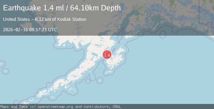
| VYTPrimary | 1.6 | 50 km | 2 days ago |
| USGS | 1.4 | 64 km | 2 days ago |
Earthquake Details
AutomaticEvent IDvyt_3ftce5107ddjw
Tsunami PotentialNo
Magnitude Typeearthquake
Nearest Places
- Cape Ilktugitak3.4 km
- Dakavak Bay4.7 km
- Posliedni Point9.1 km
- Amalik Bay Archeological District10.0 km
- Takli Island10.2 km
Comments
Join the discussion about this event.
Latest Earthquakes
2.5Mag
South of Java, Indonesia
Time1 hour ago
Depth10.40 km
SourceBMKG
2.7Mag
Near North Coast of West Papua
Time1 hour ago
Depth45.06 km
SourceBMKG
1.2Mag
Central Alaska
Time1 hour ago
Depth0.85 km
SourceVYT (Automatic)
2.6Mag
West Papua Region, Indonesia
Time1 hour ago
Depth10.00 km
SourceBMKG
2.3Mag
WESTERN TURKEY
Time1 hour ago
Depth10.10 km
SourceKOERI (Automatic)
Nearby Earthquakes
3.0Mag
ALASKA PENINSULA
Time4 years ago
Depth100.00 km
SourceNEIC (Automatic)
3.0Mag
ALASKA PENINSULA
Time9 years ago
Depth90.00 km
SourceNEIR (Automatic)
1.3Mag
60 km NNW of Karluk, Alaska
Time3 weeks ago
Depth5.00 km
SourceUSGS (Automatic)
1.5Mag
61 km N of Karluk, Alaska
Time3 weeks ago
Depth83.80 km
SourceUSGS (Automatic)
1.3Mag
Kodiak Island region, Alaska
Time2 days ago
Depth33.20 km
SourceVYT (Automatic)