Earthquake Northern Molucca Sea
Sun, 01 Feb 2026 18:20:49 GMT
Time1 day ago
Location
2.8491, 126.3757
Depth
7.4 KM
Event Summary
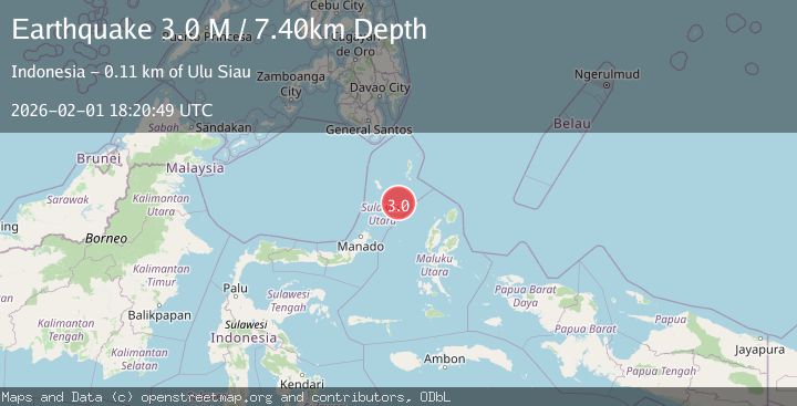
A 3.0 magnitude earthquake struck on Northern Molucca Sea, at Sun, 01 Feb 2026 18:20:49 GMT. Depth: 7.400855km. Reviewed by BMKG seismologists, this minor quake occurred at a magnitude type of M.
Magnitude
3.0
M
Source
BMKG
Intensity
-
Agency Reports
1 Sources| Source | Magnitude | Depth | Time |
|---|---|---|---|
| BMKGPrimary | 3.0 | 7 km | 1 day ago |
Earthquake Details
AutomaticEvent IDbmg2026cgay
Tsunami PotentialNo
Magnitude TypeM
Nearest Places
- Pulau Batupuntieng80.9 km
- Pulau Batukemba81.0 km
- Pulau Batuluha81.1 km
- Pulau Nenung81.4 km
- Pulau Batupaliaheng81.5 km
Comments
Join the discussion about this event.
Latest Earthquakes
2.3Mag
Minahassa Peninsula, Sulawesi
Time5 minutes ago
Depth50.17 km
SourceBMKG (Automatic)
1.2Mag
11 km NE of Julian, CA
Time5 minutes ago
Depth10.31 km
SourceUSGS (Automatic)
2.5Mag
Java, Indonesia
Time13 minutes ago
Depth78.16 km
SourceBMKG (Automatic)
2.8Mag
WEST OF AUSTRALIA
Time15 minutes ago
Depth10.00 km
SourceAUST (Automatic)
1.2Mag
17 km S of Tres Pinos, CA
Time19 minutes ago
Depth6.76 km
SourceUSGS (Automatic)
Nearby Earthquakes
3.1Mag
Northern Molucca Sea
Time1 week ago
Depth61.58 km
SourceBMKG (Automatic)
3.5Mag
Northern Molucca Sea
Time1 week ago
Depth10.00 km
SourceBMKG (Automatic)
3.1Mag
Talaud Islands, Indonesia
Time4 hours ago
Depth20.17 km
SourceBMKG (Automatic)
3.1Mag
Talaud Islands, Indonesia
Time9 hours ago
Depth18.23 km
SourceBMKG (Automatic)
2.9Mag
Talaud Islands, Indonesia
Time4 hours ago
Depth40.31 km
SourceBMKG (Automatic)