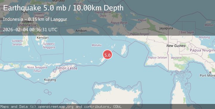
Earthquake Tanimbar Islands Region, Indonesia
Wed, 04 Feb 2026 00:36:33 GMT
Time14 hours ago
Location
-6.8666, 132.1431
Depth
101.2 KM
Event Summary
A 5.1 magnitude earthquake struck on Tanimbar Islands Region, Indonesia, at Wed, 04 Feb 2026 00:36:33 GMT. Depth: 101.189262km. Reviewed by BMKG seismologists, this moderate quake occurred at a magnitude type of M.
Magnitude
5.1
M
Source
BMKG
Intensity
-
Agency Reports
1 Sources| Source | Magnitude | Depth | Time |
|---|---|---|---|
| BMKGPrimary | 5.1 | 101 km | 14 hours ago |
Earthquake Details
AutomaticEvent IDbmg2026ckei
Tsunami PotentialNo
Magnitude TypeM
Nearest Places
- Watsira19.8 km
- Tanjung Waarlangier20.1 km
- Desa Adodo Fordata22.4 km
- Adodu23.7 km
- Walera25.8 km
Comments
Join the discussion about this event.
Latest Earthquakes
1.6Mag
3 km ESE of San Ramon, CA
Time14 hours ago
Depth0.08 km
SourceUSGS (Automatic)
2.0Mag
WESTERN TEXAS
Time15 hours ago
Depth4.40 km
SourceTX (Automatic)
4.2Mag
Banda Sea
Time15 hours ago
Depth112.63 km
SourceBMKG (Automatic)
2.7Mag
Minahassa Peninsula, Sulawesi
Time15 hours ago
Depth251.66 km
SourceBMKG (Automatic)
1.1Mag
8 km SW of Lytle Creek, CA
Time15 hours ago
Depth9.81 km
SourceUSGS (Automatic)
Nearby Earthquakes
3.8Mag
Tanimbar Islands Region, Indonesia
Time4 days ago
Depth84.48 km
SourceBMKG (Automatic)
3.5Mag
KEP. TANIMBAR REGION, INDONESIA
Time2 days ago
Depth14.00 km
SourceBMKG (Automatic)
3.3Mag
Tanimbar Islands Region, Indonesia
Time3 days ago
Depth209.05 km
SourceBMKG (Automatic)
5.2Mag
Banda Sea
Time3 days ago
Depth110.08 km
SourceBMKG (Automatic)
3.4Mag
Banda Sea
Time1 week ago
Depth159.46 km
SourceBMKG (Automatic)