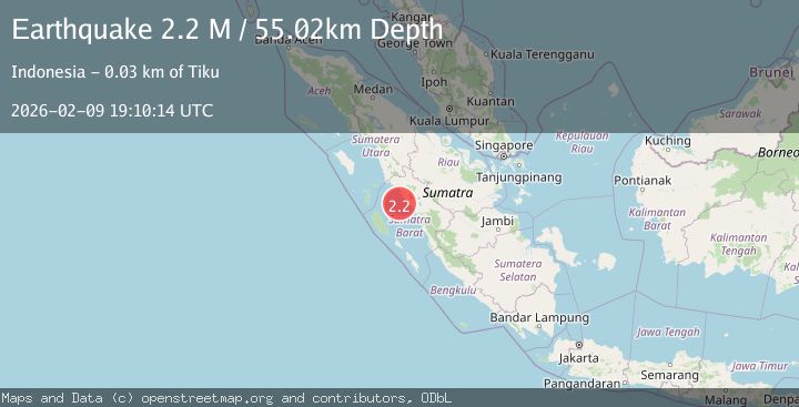
Earthquake Southern Sumatra, Indonesia
Mon, 09 Feb 2026 19:10:14 GMT
Time1 hour ago
Location
-0.6111, 99.7480
Depth
55.0 KM
Event Summary
A 2.2 magnitude earthquake struck on Southern Sumatra, Indonesia, at Mon, 09 Feb 2026 19:10:14 GMT. Depth: 55.022034km. Reviewed by BMKG seismologists, this minor quake occurred at a magnitude type of M.
Magnitude
2.2
M
Source
BMKG
Intensity
-
Agency Reports
1 Sources| Source | Magnitude | Depth | Time |
|---|---|---|---|
| BMKGPrimary | 2.2 | 55 km | 1 hour ago |
Earthquake Details
AutomaticEvent IDbmg2026cuso
Tsunami PotentialNo
Magnitude TypeM
Nearest Places
- Karang South Selita7.0 km
- Karang Selita9.1 km
- Karang Sagi10.1 km
- Karang Lawee18.8 km
- Karang Ingaris18.9 km
Comments
Join the discussion about this event.
Latest Earthquakes
1.7Mag
72 km E of Port Alsworth, Alaska
Time1 hour ago
Depth126.60 km
SourceUSGS (Automatic)
1.6Mag
26 km NNW of Valdez, Alaska
Time1 hour ago
Depth19.60 km
SourceUSGS (Automatic)
3.4Mag
ICELAND REGION
Time1 hour ago
Depth0.00 km
SourceIMO (Automatic)
2.0Mag
CENTRAL CALIFORNIA
Time1 hour ago
Depth4.60 km
SourceNC (Automatic)
3.1Mag
OFF E. COAST OF N. ISLAND, N.Z.
Time1 hour ago
Depth10.00 km
SourceGNS (Automatic)
Nearby Earthquakes
2.3Mag
Southern Sumatra, Indonesia
Time5 days ago
Depth62.22 km
SourceBMKG (Automatic)
2.8Mag
Southern Sumatra, Indonesia
Time1 week ago
Depth38.19 km
SourceBMKG (Automatic)
2.0Mag
Southern Sumatra, Indonesia
Time5 days ago
Depth4.94 km
SourceBMKG (Automatic)
4.5Mag
Southern Sumatra, Indonesia
Time1 week ago
Depth23.34 km
SourceBMKG (Automatic)
3.6Mag
Southern Sumatra, Indonesia
Time1 week ago
Depth41.61 km
SourceBMKG (Automatic)