Earthquake Timor Region
Fri, 20 Feb 2026 12:32:53 GMT
Time1 hour ago
Location
-9.8731, 123.0515
Depth
11.1 KM
Event Summary
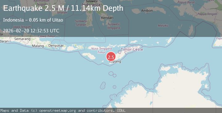
A 2.5 magnitude earthquake struck on Timor Region, at Fri, 20 Feb 2026 12:32:53 GMT. Depth: 11.144764km. Reviewed by BMKG seismologists, this minor quake occurred at a magnitude type of M.
Magnitude
2.5
M
Source
BMKG
Intensity
-
Agency Reports
1 Sources| Source | Magnitude | Depth | Time |
|---|---|---|---|
| BMKGPrimary | 2.5 | 11 km | 1 hour ago |
Earthquake Details
ManualEvent IDbmg2026dohz
Tsunami PotentialNo
Magnitude TypeM
Nearest Places
- Tanjung Bolan47.6 km
- Mumubolan48.0 km
- Onanbalu48.2 km
- Uimakas48.2 km
- Batuinan48.4 km
Comments
Join the discussion about this event.
Latest Earthquakes
3.1Mag
Timor region, Indonesia
Time1 hour ago
Depth135.01 km
SourceVYT (Automatic)
1.2Mag
2 km N of Loma Linda, CA
Time1 hour ago
Depth11.22 km
SourceUSGS (Automatic)
3.2Mag
Alaska Peninsula
Time1 hour ago
Depth10.00 km
SourceVYT (Automatic)
4.3Mag
Southwest of Sumatra, Indonesia
Time1 hour ago
Depth11.58 km
SourceBMKG
5.0Mag
southwest of Sumatra, Indonesia
Time1 hour ago
Depth10.00 km
SourceVYT (Automatic)
Nearby Earthquakes
4.0Mag
TIMOR REGION, INDONESIA
Time2 years ago
Depth10.00 km
SourceBMKG (Automatic)
5.0Mag
SAVU SEA
Time7 years ago
Depth40.00 km
SourceEMSC (Automatic)
3.4Mag
TIMOR REGION, INDONESIA
Time1 week ago
Depth254.00 km
SourceBMKG (Automatic)
2.7Mag
TIMOR REGION, INDONESIA
Time1 month ago
Depth17.00 km
SourceBMKG (Automatic)
5.0Mag
TIMOR REGION, INDONESIA
Time8 years ago
Depth61.00 km
SourceNEIC (Automatic)