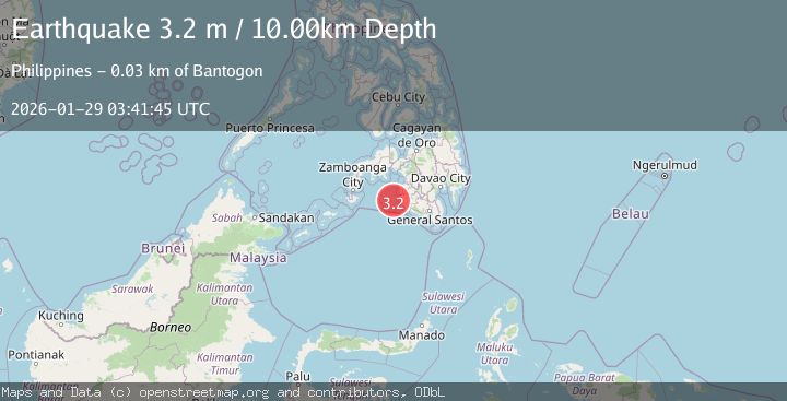
Earthquake MORO GULF, MINDANAO, PHILIPPINES
Thu, 29 Jan 2026 03:41:45 GMT
Time1 week ago
Location
6.5300, 123.7400
Depth
10.0 KM
Event Summary
A 3.2 magnitude earthquake struck on MORO GULF, MINDANAO, PHILIPPINES, at Thu, 29 Jan 2026 03:41:45 GMT. Depth: 10km. Reviewed by PIVS seismologists, this minor quake occurred at a magnitude type of m.
Magnitude
3.2
m
Source
PIVS
Intensity
-
Agency Reports
1 Sources| Source | Magnitude | Depth | Time |
|---|---|---|---|
| PIVSPrimary | 3.2 | 10 km | 1 week ago |
Earthquake Details
AutomaticEvent IDemsc_PIVS_20260129_0000063
Tsunami PotentialNo
Magnitude Typem
Nearest Places
- Donaung Shoals27.2 km
- Nara Point31.0 km
- Pidtaguinan Point31.4 km
- Point Pitas31.7 km
- Pitas32.1 km
Comments
Join the discussion about this event.
Latest Earthquakes
1.3Mag
10 km NE of Coahoma, Texas
Time10 minutes ago
Depth2.85 km
SourceUSGS (Automatic)
1.3Mag
Southern Alaska
Time11 minutes ago
Depth74.46 km
SourceVYT (Automatic)
2.9Mag
OFFSHORE NORTHERN CALIFORNIA
Time11 minutes ago
Depth16.70 km
SourceNC (Automatic)
2.4Mag
southern Sumatra, Indonesia
Time20 minutes ago
Depth0.00 km
SourceVYT (Automatic)
2.4Mag
Java, Indonesia
Time20 minutes ago
Depth53.60 km
SourceBMKG
Nearby Earthquakes
4.6Mag
MORO GULF, MINDANAO, PHILIPPINES
Time1 week ago
Depth6.00 km
SourcePIVS (Automatic)
3.5Mag
MORO GULF, MINDANAO, PHILIPPINES
Time4 hours ago
Depth3.00 km
SourcePIVS (Automatic)
3.2Mag
MORO GULF, MINDANAO, PHILIPPINES
Time1 week ago
Depth10.00 km
SourcePIVS (Automatic)
3.3Mag
MORO GULF, MINDANAO, PHILIPPINES
Time1 week ago
Depth6.00 km
SourcePIVS (Automatic)
3.4Mag
MORO GULF, MINDANAO, PHILIPPINES
Time2 weeks ago
Depth22.00 km
SourcePIVS (Automatic)