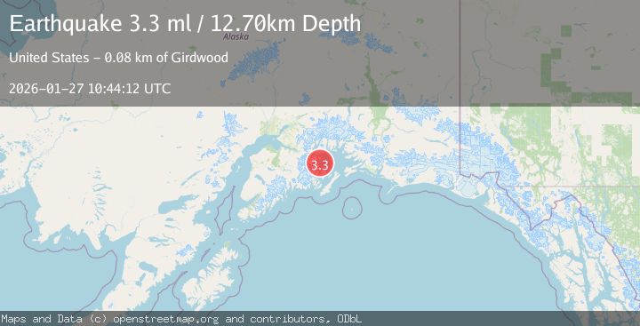
Earthquake 45 km NW of Tatitlek, Alaska
Tue, 27 Jan 2026 09:58:47 GMT
Time2 hours ago
Location
61.1290, -147.3290
Depth
13.6 KM
Event Summary
A 3.5 magnitude earthquake struck on 45 km NW of Tatitlek, Alaska, at Tue, 27 Jan 2026 09:58:47 GMT. Depth: 13.6km. Reviewed by USGS seismologists, this minor quake occurred at a magnitude type of ml.
Magnitude
3.5
ml
Source
USGS
Intensity
-
Agency Reports
2 Sources| Source | Magnitude | Depth | Time |
|---|---|---|---|
| USGSPrimary | 3.3 | 13 km | 1 hour ago |
| AK | 3.5 | 20 km | 1 hour ago |
Earthquake Details
AutomaticEvent IDusgs_ak2026bwmswt
Tsunami PotentialNo
Magnitude Typeml
Nearest Places
- Pedro Glacier0.9 km
- Brilliant Glacier6.2 km
- Mount Grosvenor8.1 km
- Miners Lake8.2 km
- Kadin Lake8.3 km
Comments
Join the discussion about this event.
Latest Earthquakes
3.7Mag
VALPARAISO, CHILE
Time5 minutes ago
Depth27.60 km
SourceCSN (Automatic)
2.0Mag
CENTRAL TURKEY
Time8 minutes ago
Depth23.50 km
SourceKOERI (Automatic)
3.2Mag
OFFSHORE EL SALVADOR
Time9 minutes ago
Depth28.00 km
SourceINET (Automatic)
3.1Mag
South of Java, Indonesia
Time9 minutes ago
Depth5.01 km
SourceBMKG (Automatic)
2.2Mag
Near North Coast of West Papua
Time12 minutes ago
Depth10.00 km
SourceBMKG (Automatic)
Nearby Earthquakes
1.3Mag
47 km WNW of Tatitlek, Alaska
Time3 days ago
Depth5.00 km
SourceUSGS (Automatic)
1.5Mag
52 km WNW of Tatitlek, Alaska
Time4 days ago
Depth7.30 km
SourceUSGS (Automatic)
1.9Mag
42 km WNW of Valdez, Alaska
Time1 hour ago
Depth9.20 km
SourceUSGS
1.8Mag
22 km NW of Tatitlek, Alaska
Time13 hours ago
Depth13.70 km
SourceUSGS
2.1Mag
22 km WNW of Tatitlek, Alaska
Time1 day ago
Depth20.30 km
SourceUSGS (Automatic)