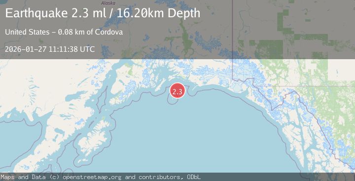
Earthquake 81 km S of Cordova, Alaska
Tue, 27 Jan 2026 11:11:37 GMT
Time2 hours ago
Location
59.8170, -145.8580
Depth
26.1 KM
Event Summary
A 2.4 magnitude earthquake struck on 81 km S of Cordova, Alaska, at Tue, 27 Jan 2026 11:11:37 GMT. Depth: 26.1km. Reviewed by USGS seismologists, this minor quake occurred at a magnitude type of ml.
Magnitude
2.4
ml
Source
USGS
Intensity
-
Agency Reports
1 Sources| Source | Magnitude | Depth | Time |
|---|---|---|---|
| USGSPrimary | 2.4 | 26 km | 2 hours ago |
Earthquake Details
AutomaticEvent IDusgs_ak2026bwpdqr
Tsunami PotentialNo
Magnitude Typeml
Nearest Places
- Wessels Reef Buoy 113.4 km
- Wessels Reef18.4 km
- Gulf of Alaska22.5 km
- Garden Island23.4 km
- Fountain Rock37.9 km
Comments
Join the discussion about this event.
Latest Earthquakes
1.8Mag
20 km WSW of Point MacKenzie, Alaska
Time3 hours ago
Depth51.40 km
SourceUSGS (Automatic)
1.8Mag
10 km WSW of Pepeekeo, Hawaii
Time3 hours ago
Depth36.48 km
SourceUSGS (Automatic)
3.5Mag
SALTA, ARGENTINA
Time3 hours ago
Depth185.00 km
SourceNSNA (Automatic)
1.5Mag
3 km SE of Pacifica, CA
Time3 hours ago
Depth9.45 km
SourceUSGS (Automatic)
2.5Mag
TURKEY-IRAN BORDER REGION
Time3 hours ago
Depth7.00 km
SourceAFAD (Automatic)
Nearby Earthquakes
2.8Mag
40 km ESE of Cordova, Alaska
Time5 days ago
Depth27.10 km
SourceUSGS (Automatic)
2.8Mag
47 km E of Cordova, Alaska
Time6 days ago
Depth16.90 km
SourceUSGS (Automatic)
1.2Mag
19 km S of Tatitlek, Alaska
Time2 days ago
Depth26.20 km
SourceUSGS (Automatic)
1.8Mag
56 km NE of Chenega, Alaska
Time5 days ago
Depth20.90 km
SourceUSGS (Automatic)
1.5Mag
27 km NNE of Chenega, Alaska
Time3 days ago
Depth18.70 km
SourceUSGS (Automatic)