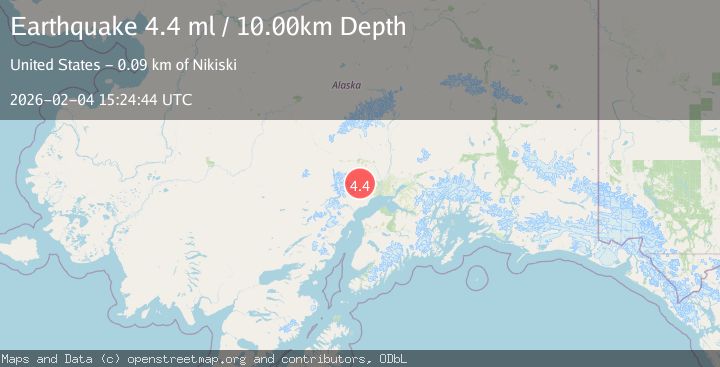
Earthquake 46 km NW of Beluga, Alaska
Wed, 04 Feb 2026 15:24:45 GMT
Time1 hour ago
Location
61.4880, -151.5620
Depth
99.7 KM
Event Summary
A 4.6 magnitude earthquake struck on 46 km NW of Beluga, Alaska, at Wed, 04 Feb 2026 15:24:45 GMT. Depth: 99.7km. Reviewed by USGS seismologists, this light quake occurred at a magnitude type of ml.
Magnitude
4.6
ml
Source
USGS
Intensity
-
Agency Reports
1 Sources| Source | Magnitude | Depth | Time |
|---|---|---|---|
| USGSPrimary | 4.6 | 100 km | 1 hour ago |
Earthquake Details
AutomaticEvent IDusgs_ak2026clpiur
Tsunami PotentialNo
Magnitude Typeml
Nearest Places
- Coal Creek Lake0.3 km
- West Fork Coal Creek3.8 km
- Kitty Lake6.0 km
- Coal Creek9.1 km
- Judd Lake9.1 km
Comments
Join the discussion about this event.
Latest Earthquakes
1.4Mag
9 km E of Alum Rock, CA
Time1 hour ago
Depth-0.45 km
SourceUSGS (Automatic)
2.2Mag
Northern Sumatra, Indonesia
Time1 hour ago
Depth24.31 km
SourceBMKG (Automatic)
2.4Mag
Java, Indonesia
Time2 hours ago
Depth51.87 km
SourceBMKG (Automatic)
2.1Mag
Southern Sumatra, Indonesia
Time2 hours ago
Depth3.99 km
SourceBMKG (Automatic)
2.1Mag
Near North Coast of West Papua
Time2 hours ago
Depth21.79 km
SourceBMKG (Automatic)
Nearby Earthquakes
2.3Mag
34 km NW of Beluga, Alaska
Time1 week ago
Depth83.70 km
SourceUSGS (Automatic)
2.1Mag
43 km WNW of Beluga, Alaska
Time3 days ago
Depth98.60 km
SourceUSGS (Automatic)
0.7Mag
62 km WNW of Beluga, Alaska
Time1 day ago
Depth5.00 km
SourceUSGS (Automatic)
2.7Mag
27 km SSE of Skwentna, Alaska
Time1 week ago
Depth77.80 km
SourceUSGS (Automatic)
2.1Mag
49 km WNW of Beluga, Alaska
Time2 days ago
Depth103.90 km
SourceUSGS (Automatic)