Earthquake 49 km NW of Toyah, Texas
Sun, 22 Feb 2026 08:39:08 GMT
Time1 hour ago
Location
31.6560, -104.1360
Depth
4.2 KM
Event Summary
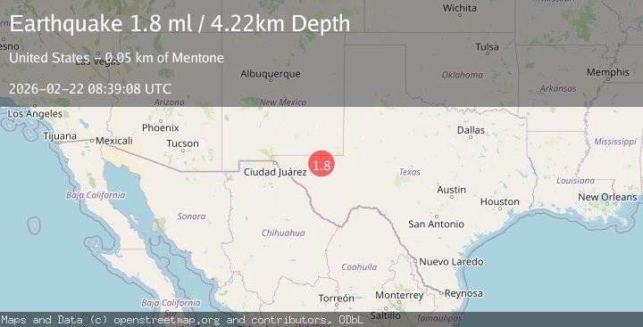
A 1.8 magnitude earthquake struck on 49 km NW of Toyah, Texas, at Sun, 22 Feb 2026 08:39:08 GMT. Depth: 4.2243km. Reviewed by USGS seismologists, this minor quake occurred at a magnitude type of ml.
Magnitude
1.8
ml
Source
USGS
Intensity
-
Agency Reports
1 Sources| Source | Magnitude | Depth | Time |
|---|---|---|---|
| USGSPrimary | 1.8 | 4 km | 1 hour ago |
Earthquake Details
AutomaticEvent IDusgs_tx2026dsczdd
Tsunami PotentialNo
Magnitude Typeml
Nearest Places
- 2.5 km
- 2.8 km
- 4.5 km
- 4.9 km
- 5.0 km
Comments
Join the discussion about this event.
Latest Earthquakes
1.5Mag
Fox Islands, Aleutian Islands, Alaska
Time34 minutes ago
Depth40.77 km
SourceVYT (Automatic)
1.3Mag
13 km SW of Searles Valley, CA
Time37 minutes ago
Depth4.25 km
SourceUSGS (Automatic)
2.7Mag
Near North Coast of West Papua
Time45 minutes ago
Depth17.60 km
SourceBMKG
1.3Mag
22 km E of Anderson, Alaska
Time45 minutes ago
Depth14.10 km
SourceUSGS (Automatic)
2.6Mag
OFFSHORE EL SALVADOR
Time47 minutes ago
Depth31.00 km
SourceINET (Automatic)
Nearby Earthquakes
2.2Mag
WESTERN TEXAS
Time1 month ago
Depth5.50 km
SourceTX (Automatic)
1.8Mag
49 km NW of Toyah, Texas
Time4 days ago
Depth3.95 km
SourceUSGS (Automatic)
1.7Mag
western Texas
Time2 days ago
Depth0.00 km
SourceVYT (Automatic)
2.0Mag
western Texas
Time4 days ago
Depth0.12 km
SourceVYT (Automatic)
1.7Mag
50 km W of Mentone, Texas
Time4 days ago
Depth5.67 km
SourceUSGS (Automatic)