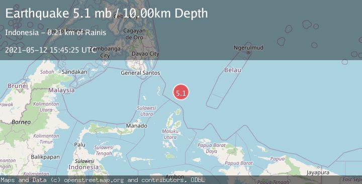
Earthquake NORTH OF HALMAHERA, INDONESIA
Wed, 12 May 2021 15:45:25 GMT
Time4 years ago
Location
4.0800, 128.7300
Depth
10.0 KM
Event Summary
A 5.1 magnitude earthquake struck on NORTH OF HALMAHERA, INDONESIA, at Wed, 12 May 2021 15:45:25 GMT. Depth: 10km. Reviewed by EMSC seismologists, this moderate quake occurred at a magnitude type of mb.
Magnitude
5.1
mb
Source
EMSC
Intensity
-
Agency Reports
1 Sources| Source | Magnitude | Depth | Time |
|---|---|---|---|
| EMSCPrimary | 5.1 | 10 km | 4 years ago |
Earthquake Details
AutomaticEvent IDemsc_EMSC_20210512_0000141
Tsunami PotentialNo
Magnitude Typemb
Nearest Places
- Snellius Ridge81.5 km
- Morotai Basin144.9 km
- Talaud Trough145.9 km
- Tanjung Sopi160.7 km
- Pulau Karis161.7 km
Comments
Join the discussion about this event.
Latest Earthquakes
1.4Mag
Kenai Peninsula, Alaska
Time4 minutes ago
Depth1.95 km
SourceVYT (Automatic)
3.1Mag
Northern Sumatra, Indonesia
Time5 minutes ago
Depth14.69 km
SourceBMKG
1.9Mag
Channel Islands region, California
Time5 minutes ago
Depth2.81 km
SourceVYT (Automatic)
3.3Mag
Southern Alaska
Time12 minutes ago
Depth13.06 km
SourceVYT (Automatic)
1.9Mag
Southern Yukon Territory, Canada
Time13 minutes ago
Depth0.00 km
SourceVYT (Automatic)
Nearby Earthquakes
5.5Mag
NORTH OF HALMAHERA, INDONESIA
Time4 years ago
Depth61.00 km
SourceEMSC (Automatic)
5.2Mag
NORTH OF HALMAHERA, INDONESIA
Time1 year ago
Depth53.00 km
SourceEMSC (Automatic)
4.6Mag
North of Halmahera, Indonesia
Time6 hours ago
Depth14.71 km
SourceBMKG
4.2Mag
North of Halmahera, Indonesia
Time5 days ago
Depth67.37 km
SourceBMKG
4.3Mag
North of Halmahera, Indonesia
Time2 days ago
Depth59.15 km
SourceBMKG