Earthquake SAN FRANCISCO BAY AREA, CALIF.
Sat, 10 Jan 2026 01:54:35 GMT
Time1 month ago
Location
37.9565, -122.1655
Depth
6.0 KM
Event Summary
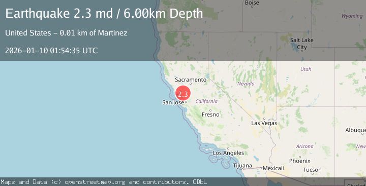
A 2.3 magnitude earthquake struck on SAN FRANCISCO BAY AREA, CALIF., at Sat, 10 Jan 2026 01:54:35 GMT. Depth: 6km. Reviewed by NC seismologists, this minor quake occurred at a magnitude type of md.
Magnitude
2.3
md
Source
NC
Intensity
-
Agency Reports
1 Sources| Source | Magnitude | Depth | Time |
|---|---|---|---|
| NCPrimary | 2.3 | 6 km | 1 month ago |
Earthquake Details
AutomaticEvent IDemsc_NC_20260110_0000026
Tsunami PotentialNo
Magnitude Typemd
Nearest Places
Comments
Join the discussion about this event.
Latest Earthquakes
1.5Mag
Southern Alaska
Time1 day ago
Depth67.26 km
SourceVYT (Automatic)
2.4Mag
Northern Sumatra, Indonesia
Time1 day ago
Depth12.76 km
SourceBMKG
1.2Mag
10 km NW of The Geysers, CA
Time1 day ago
Depth1.41 km
SourceUSGS (Automatic)
1.0Mag
Southern Alaska
Time1 day ago
Depth14.53 km
SourceVYT (Automatic)
3.5Mag
Kepulauan Mentawai region, Indonesia
Time1 day ago
Depth29.42 km
SourceVYT (Automatic)
Nearby Earthquakes
1.1Mag
4 km WNW of Orinda, CA
Time3 weeks ago
Depth3.94 km
SourceUSGS (Automatic)
1.7Mag
1 km NNE of Pleasant Hill, CA
Time3 days ago
Depth10.81 km
SourceUSGS (Automatic)
3.0Mag
SAN FRANCISCO BAY AREA, CALIF.
Time7 years ago
Depth16.00 km
SourceNC (Automatic)
3.0Mag
SAN FRANCISCO BAY AREA, CALIF.
Time10 years ago
Depth14.00 km
SourceNC (Automatic)
3.0Mag
SAN FRANCISCO BAY AREA, CALIF.
Time10 years ago
Depth13.00 km
SourceNC (Automatic)