Earthquake 78 km SW of Nanwalek, Alaska
Sat, 24 Jan 2026 00:12:11 GMT
Time1 week ago
Location
58.7830, -152.7040
Depth
30.2 KM
Event Summary
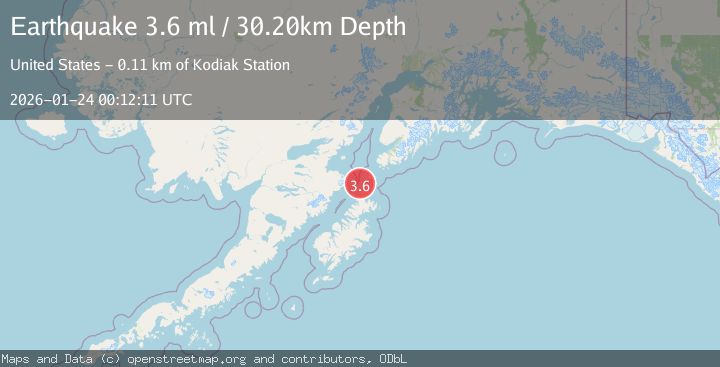
A 3.6 magnitude earthquake struck on 78 km SW of Nanwalek, Alaska, at Sat, 24 Jan 2026 00:12:11 GMT. Depth: 30.2km. Reviewed by USGS seismologists, this minor quake occurred at a magnitude type of ml.
Magnitude
3.6
ml
Source
USGS
Intensity
-
Agency Reports
2 Sources| Source | Magnitude | Depth | Time |
|---|---|---|---|
| USGSPrimary | 3.6 | 30 km | 1 week ago |
| AK | 3.6 | 30 km | 1 week ago |
Earthquake Details
AutomaticEvent IDusgs_ak2026bqgcqb
Tsunami PotentialNo
Magnitude Typeml
Nearest Places
- Stevenson Entrance15.6 km
- Latax Rocks16.3 km
- Dark Island18.0 km
- Dark Passage18.9 km
- Shag Island19.1 km
Comments
Join the discussion about this event.
Latest Earthquakes
3.5Mag
West Papua Region, Indonesia
Time2 hours ago
Depth10.00 km
SourceBMKG (Automatic)
3.1Mag
5 km SE of San Ramon, CA
Time2 hours ago
Depth6.47 km
SourceUSGS (Automatic)
4.1Mag
Northern Sumatra, Indonesia
Time2 hours ago
Depth10.00 km
SourceBMKG (Automatic)
4.1Mag
BANGLADESH
Time2 hours ago
Depth150.00 km
SourceNDI (Automatic)
0.7Mag
7 km NW of The Geysers, CA
Time2 hours ago
Depth3.13 km
SourceUSGS (Automatic)
Nearby Earthquakes
3.8Mag
KODIAK ISLAND REGION, ALASKA
Time1 week ago
Depth68.20 km
SourceAK (Automatic)
3.3Mag
KODIAK ISLAND REGION, ALASKA
Time5 hours ago
Depth19.20 km
SourceAK (Automatic)
2.8Mag
76 km NNE of Aleneva, Alaska
Time5 hours ago
Depth26.90 km
SourceUSGS (Automatic)
2.0Mag
61 km NNW of Aleneva, Alaska
Time1 week ago
Depth61.80 km
SourceUSGS (Automatic)
2.7Mag
15 km SSW of Nanwalek, Alaska
Time1 week ago
Depth43.50 km
SourceUSGS