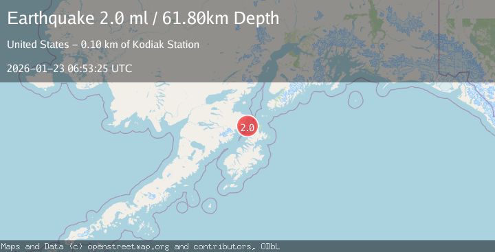
Earthquake 61 km NNW of Aleneva, Alaska
Fri, 23 Jan 2026 06:53:25 GMT
Time1 week ago
Location
58.5890, -153.2240
Depth
61.8 KM
Event Summary
A 2.0 magnitude earthquake struck on 61 km NNW of Aleneva, Alaska, at Fri, 23 Jan 2026 06:53:25 GMT. Depth: 61.8km. Reviewed by USGS seismologists, this minor quake occurred at a magnitude type of ml.
Magnitude
2.0
ml
Source
USGS
Intensity
-
Agency Reports
1 Sources| Source | Magnitude | Depth | Time |
|---|---|---|---|
| USGSPrimary | 2.0 | 62 km | 1 week ago |
Earthquake Details
AutomaticEvent IDusgs_ak2026boxrpp
Tsunami PotentialNo
Magnitude Typeml
Nearest Places
- Douglas Reef19.5 km
- Kiukpalik Island19.5 km
- Shakun Rock27.2 km
- Rocky Island27.6 km
- Black Cape28.1 km
Comments
Join the discussion about this event.
Latest Earthquakes
2.3Mag
Flores Region, Indonesia
Time2 hours ago
Depth17.19 km
SourceBMKG (Automatic)
3.6Mag
Sumbawa Region, Indonesia
Time2 hours ago
Depth14.84 km
SourceBMKG (Automatic)
3.5Mag
West Papua Region, Indonesia
Time2 hours ago
Depth10.00 km
SourceBMKG (Automatic)
3.1Mag
5 km SE of San Ramon, CA
Time2 hours ago
Depth6.47 km
SourceUSGS (Automatic)
4.1Mag
Northern Sumatra, Indonesia
Time2 hours ago
Depth10.00 km
SourceBMKG (Automatic)
Nearby Earthquakes
3.6Mag
78 km SW of Nanwalek, Alaska
Time1 week ago
Depth30.20 km
SourceUSGS (Automatic)
3.8Mag
KODIAK ISLAND REGION, ALASKA
Time1 week ago
Depth68.20 km
SourceAK (Automatic)
3.3Mag
KODIAK ISLAND REGION, ALASKA
Time5 hours ago
Depth19.20 km
SourceAK (Automatic)
2.4Mag
67 km WNW of Aleneva, Alaska
Time4 days ago
Depth71.70 km
SourceUSGS (Automatic)
2.8Mag
76 km NNE of Aleneva, Alaska
Time5 hours ago
Depth26.90 km
SourceUSGS (Automatic)